Assumptions when doing Parcels
1. You are using either Civil 3D 2007 OR Civil 3D 2006 with SP1, SP2, HF2 installed
2. You have a general understanding of parcels from a class, tutorials or AUGI ATP
Parcel Rules*
*I made these up based on my own experiences doing my own site plans and pilot projects with clients. I am getting this information empirically based on trial, error, blood, sweat and tears, not because I know how the programmers define parcels, etc. These are tools that I find work well. But I can make no guarantees that you will have a flawless project if you follow them. But following them WILL help.
1. Parcels always close.
2. Parcels never have "vacuums".
3. Parcels don't like to be "leaky buckets".
4. Parcels don't like to have "hanging chads".
5. Parcels keep getting smaller.
6.Parcels behave best with "Two Parcels, One Lot Line"
7. Parcels can be defined from closed polylines- but they don't always like it!
8. Parcels can be migrated from Land Desktop or through LandXML- but they don't always like it!
9. Parcels cannot be erased, but Parcel Segments (Lot Lines) can be erased.
10. Parcels will react with geometry on their same site, such as other parcels and alignments.
11. Parcels defined to be ROW are not magic.
12. Parcels are picked by their area label.
13. When making revisions, erase lot lines from the "inside-> out"
14. Disable Autosave. Use REAL Save. Learn how to use audit and fix your "Rule Violations" before save.
***AS ALWAYS- Click on any image to get a full sized version. I am still working out my screen capture skillz, so I hope they are reasonable to read. I will get better!***
1. Parcels Always Close
If you have a lot survey and it doesn't close, it is not a good idea to define it as a parcel "as is". (See Number 4- Leaky Bucket)
2. Parcels Never Have Vacuums
Once you have defined an area as a parcel, every time you add a parcel within its boundaries, new parcels are born. It doesn't matter if you never thought of wetlands as a parcel or ROW as a parcel- in Civil 3D's mind, they are indeed parcels.
But you say- I don't want it labeled like that! That's cool. Just make a label style you can live with. Something that says "ROW" for example, or "Paved Area" and doesn't call out the area. Or, maybe just a number (example below) or even a "None" label that shows nothing.
3. Parcels Don't like to be "Leaky Buckets"
This goes along with Rule Number 1. Parcels must close. I meant it.
Why?
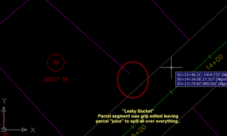
I am not 100% sure, but I picture it as my parcel "juice" is spilling out all over the drawing and Civil 3D wants all of that juice inside the parcel.
So whenever it regens (like a save) it tries really hard to stuff all of that juice back into the parcel, and if it can't- it gets very very mad.
Common errors include- Multiple Area Labels on what you think is the same parcel, drawing crashes, inability to use layout tools properly (like not recognizing all of your frontage, etc). Even TINY holes can leak parcel juice.
Fixes- Use Create by Layout tools such as Freeform Create, etc. that project backwards to the nearest parcel segment and close for you even when you make edits. If defining parcels by lines or polyline, make sure they close using the pedit command, etc.
4. Parcels Don't like to have "Hanging Chads"
Hanging Chad refers to lot lines that are "hanging" over the edge. This often happens when you are grip editing or not being careful about using your nearest osnap when drawing lot lines.
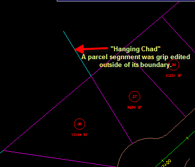 Hanging Chads are a bit like Leaky Buckets. In the picture below, Civil 3D is trying to make 4 parcels. Obviously, Lot 37 and its neighbor, but also the other two on the other side of the pink line.
There is parcel juice leaking all over the place here and it can cause problems such as: the "Phantom Parcel" in your toolspace, drawing errors or others.
Another type of Hanging Chad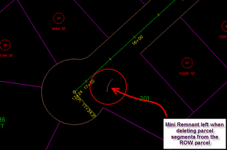 is the "Mini Remnant" left over from incomplete erasure of lot lines. This one is a killer. It sees the world as its lot line. Don't get caught here- erase your lot lines completely.
5. Parcels keep getting smaller.
See Rule Number 2. As you add more lot lines inside of an already defined parcel, the original parcel continues to get smaller. "But what if I need to keep my boundary intact?" you ask. Well, that is where sites come in. See Rule Number 10.
Steps:
--Make your boundary parcel on a Site called "Boundary"
--Copy your boundary parcel onto a Site called "Roads and Lots"
--Break out your cookie cutter and subdivide away. You original boundary is intact for use in other situations.
6. Parcels behave best with "Two Parcels, One Lot Line"
When there are two parcels next to each other, you need to define just ONE lot line. This is really important.
For example, let's say I have a boundary.
And I want to make an easement that goes along one side of the property. I will use ONE line to define it, and NOT trace over the existing outer boundary. The black line in the shot below is just a regular AutoCAD line that touches both sides of the boundary. I do NOT want to continue my black line to trace over the sides or top of this boundary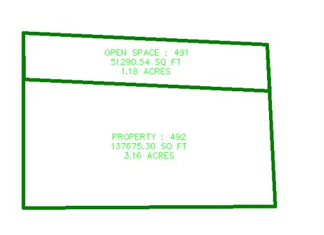
I can say- Parcels>Define From Objects and Pick that line. Alternatively, I could use any Parcel Layout creation tool.
Any edits to any of these lot lines make for seamless reactions in area and labeling from the parcels in question. (Keep your eyes open for hanging chads of course, though, as you grip edit.)
Here is what NOT to do and why.
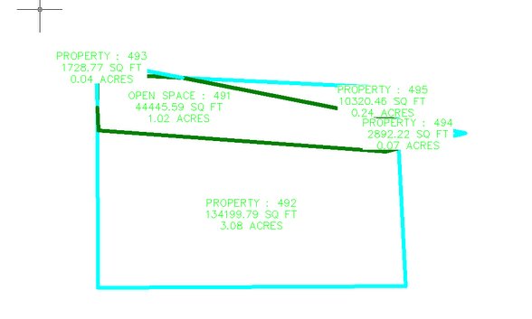
You get this potential mess upon grip editing.
This leads to leaky buckets and weirdness all around, as well as draw order issues, etc. Other common problems that result from this: Zero Area Parcels, Phantom Labels, Unexpected areas, and drawing errors.
7. Parcels can be defined from closed polylines- but they don't always like it!
This is an application of Rule Number 6. Parcels don't like to have to think about things too much. Having lot line over lot line is too much to think about.
Parcels that are good to define from closed polylines most of the time:
--Furthest Outer Boundary
--Internal "Islands" like isolated wetlands, maybe SWM areas or open space.
--ROW (although most of the time ROW has at least one end where it is tying into boundary, and therefore wouldn't really be an island)
Parcels NEVER EVER to define from polylines:
--Subdivision lots.
Only do this if you want to make a drawing that nobody can ever open again. I mean corruption city. Do NOT do this.
The worst thing you can do to yourself is to say "This is my First Civil 3D Project. I am still learning parcels. Because I am still learning, I am just going to trace all of my lots with closed polylines and work with them that way. They won't change, the client has made his decisions." THEY WILL CHANGE. And you will be veeeeeeeeeeeeeeery sorry. Better to leave them as dumb lines, arcs, and curves that do this.
--Anything that is a candidate for "Two Parcels, One Lot Line"
8. Parcels can be migrated from Land Desktop or through LandXML- but they don't always like it!
Same reasons as Rule Number 7. Land Desktop Migrated or LandXML'ed parcels are brought in as if they were closed polylines (or sometimes other weird segments). They behave poorly for the same reasons. They have caused me many corruptions. Don't do it. Better to leave them as dumb lines, arcs, curves.
9. Parcels cannot be erased, but Parcel Segments (Lot Lines) can be erased.
Usually, your first attempt to erase a parcel occurs somewhere in the range of Rule Number 2. You say, "but a ROW isn't a parcel! Just lots are parcels!" and you try to erase the ROW parcel by picking its parcel label. And you notice that doesn't do anything.
You can use AutoCAD erase, or the Parcel>Edit Parcel Segments tools. If you originally defined your parcel segment with a closed polyline and you use AutoCAD erase, it will erase the entire segment as the original polyline (ie your entire site ROW or wetlands boundary).
If you use the Parcel>Edit Parcel Segments tools, it sees them as "line" segments. So if you need to erase just one little piece of your ROW, use those tools.
Parcels are thought of by Civil 3D as "areas bounded by parcel segments (aka lot lines)". In order to erase a Parcel, you need to erase all of the lot lines that define it. Since parcels can never have internal vacuums, when you erase lot lines, adjacent parcels will gobble up the area those lines left behind. Keep in mind Rule Number 4 and don't leave any Hanging Chads or Mini Remnants.
10. Parcels will react with geometry on their same site, such as other parcels and alignments.
This is great- when you want it to happen. This makes for drawing errors and random acts of Civil 3D violence when you didn't realize what was happening.
The most common culprit- Alignments.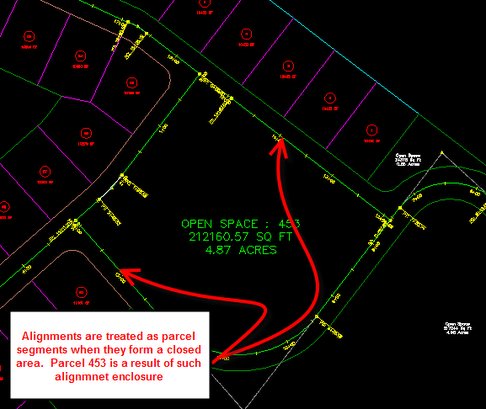 Alignments are treated the same as parcel segments when the cross through a parcel. They are also treated as parcel segments when they close on themselves or meet other alignments.
And NO, you cannot erase these parcels. See Rule Number 9.
This is fine when your "Roads and Lots" are interacting. This is NOT fine when the alignment representing a pipe run is crossing through a subdivision lot, or zigzagging around your road centerline. 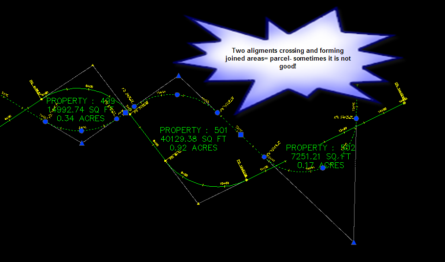
NOT ADDRESSING THIS PROBLEM LEADS TO DRAWING INSTABILITY.
How to deal with this:
Make Sites for each group of geometry that should react to each other such as:
Boundary
Roads and Lots
Sanitary Sewers
Storm Drains
Water Lines
etc
Use care when creating geometry to choose the correct site.
Any parcels that form that are correct, but you don't want to see their label, just apply a "No Show" Label to them.
11. Parcels defined to be ROW are not magic.
The Parcels>Create ROW tool is just a combination offset/join/fillet/define from objects command.
It is not magic.
It cannot create cul de sacs or knuckles or other things along those lines. You can accomplish the same thing yourself (and in my opinion often better) when you offset your alignment, make culdesacs using circles, fillet and trim, and Define From Objects.
Moving your alignment after your parcel is defined does not automatically make every lot you have laid out magically move the way you want.
This is the result you get if you try that. And it is ugly. See Rule Number 13 for strategy on how to avoid this problem.
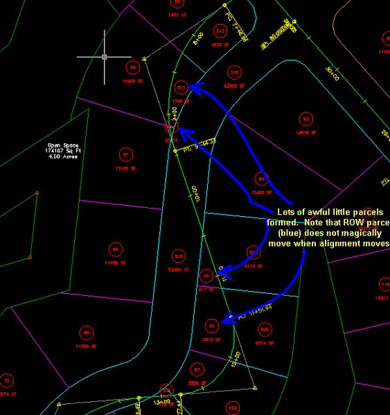 Before Moving (Left)
After Moving (Right)
12. Parcels are picked by their area label.
Whenever Civil 3D asks you to "Choose Parcel" or "Pick Parcel" it wants you to choose an area label. NOT a parcel segment/lot line.
13. When making revisions, erase lot lines from the "inside-> out"
Not a magic bullet, but this is what I find works best when you are trying to revise an alignment and redo your parcels.
Start Erasing from the INSIDE-> OUT
For example:
Erase Individual Lot Lines
Erase ROW
If necessary, erase Back of Lot Target Line
Pay attention- don't leave hanging chads or leaky buckets as you work
Revise alignment
Re-offset and make new ROW
Re-offset and make new Back of Lot Target Line, if necessary
Re-Layout Lots
14. Disable Autosave. Use REAL Save. Learn how to use audit and fix your "Rule Violations" before save.
Every time you save, Civil 3D tries to regen. If you have a drawing chock full of errors, parcel juice and other junk, it will crash on save. Not pretty. Autosave will kill you here.
So you make some edits, and before you have a chance to erase the hanging chads, the phone rings. Autosave kicks in while you are on the phone and you are crashed.
Recovering drawings is a waste of time in my opinion. The really good hard crashes destroy any chance you have of coming back to life.
To prevent this:
-Turn your autosave OFF. Yes, I did say that. OFF.
-Check your drawing for violations of the Rules.
-Use audit. Type "Audit" in the command line. Have it fix errors. (note: sometimes audit can cause a crash for the same reasons. If you run it first without fixing errors, it will alert you to some problems. Check your buckets and chads. Then run it again to fix the errors.)
-Save your drawing using the Save Button or File>Save (I added mine to my tool palette)
-When parceling, save every 10 minutes or so. I haven't used autosave in years, it is just habit to hit the button.
-Every so often, do a real backup. Not the worthless .bak file, I mean- -File>Save-As in some safe place.
-I often do a File>Save-As of my drawing as it looks with just Boundary, Back of Lots, ROW and Alignments and start with that one for revisions.
-Use the "Regen" command with the same caution as save. Also in that category is Plot, amongst others
These are just things that have worked for me. I'd love feedback!




5 Comments:
Excellent. Perhaps one addition - If your alignment geometry includes spirals, it is preferable to use the ROW tool instead of offsetting and it is then mandatory to use one of the create by layout tools (slide angle, etc...) for lot creation.
Very good explanation of the do's and don'ts.
this is great- thank you so much!! I'm just getting started and this is making a lot of sense. Thanks again.
lee
Comment/Query to Kirk:
Spirals that you make sound like would be on the interior of a subdivision?
Wouldn't they normally be found along a Boundary Line of this hypothetical Subdivision Kirk?
Don Reichle
Thanks for the tips! I started using C3d for the first time doing some parcel work and started creating parcels by closed polys and my drawing got so corrupted it was useless. So I started over using your tips and viola! Everything worked fine. I did a 212 lot Subdivision with no Fatal Errors........Thanks!
Just wondering one thing.....do you know of a way to get a error closure in any of the reports?
thanks again!
Currupt drawings!!
This is rediculous! I spend more time reloading civil 3d than I do designing/learning. I admit I don't know what I'm doing yet, And Dana's sugestions of putting everything on diferent sites might be what I did wrong. I save frequently, but this is like saying wear a safty harnes when you are working on the top of a skyscraper. Thats fine, but I didn't upgrade to be put on top of the building.... Why have a program that is so damn buggy???
Wesley Ashworth
washworth@davisengineeringcompany.com
Post a Comment