No list of blogs is complete without mention of the greatest CADiva ever.
Lynn Allen's Blog
http://lynn.blogs.com/
I learn something new at LEAST three times a week from Lynn's blog. She's got it all. Looks, brains, every male AUGI heart, private jet... well I don't know about the jet. Beth and I have a bit of hero (heroine) worship for Lynn.
So this year in Dallas at our annual Nerd Round Up (aka Bootcamp) Beth, JR and I were sitting at a table eating lunch and talking about how cool Lynn is and how we'd love to meet her. JR mentioned that at AU this past year he literally bumped into her. I said "OHMIGOD, did you pluck out a hair for your scrapbook" .... And....
Just as I said that, a voice to our left said "Do you mind if I join you guys?"
And it was LYNN. True Story.
Wednesday, May 31, 2006
Another Blog and CAD-Celebrity Story
Blogs for the Hard Core

So those of you who are readers of Civil 3DRocks probably realize that we are the Susie Sushine of the Civil 3D Blog world. We don't talk a lot of Vault yet, we have a lot of health-n-beauty tips along with the technical info.
If you are looking for more of a Corn Beef Hash approach, check out these fine friends of ours.
Here are some links to some of the Civil 3D Community's Finest Gearheads:
James Wedding, PE
www.civil3d.com
Tons of real experience as a design engineer and manager, now focusing on training and implementing Civil 3D in all kinds of environments.
Great info for those wanting to launch Vault.
Danny Counts
http://digginginc3d.blogspot.com/
I am not convinced that Danny actually sleeps. I sat behind him at ICE training last year and I witnessed him simultaneously teaching an ATP, participating in class, getting every answer correct, motivating his staff back in LA and I could almost see the ideas leaking out of his ears as well. More great hard core Vault and Data Sharing Information.
Angel Espinoza
http://acecivil3d.blogspot.com/
One of the first Civil 3D blogs, great information and good reading.
Jason Hickey
http://beneaththelines.blogspot.com/
He's from Alabama. He looks good in a cape and tights. He's a Civil 3D Superhero.
Lots more out there as well!
Tuesday, May 30, 2006
Yeah Yeah... looks awful I know
I realize my blog looks horrible right now. I really want it to look nice and I am struggling with the HTML and how to make it great. Give me a few more days! :) And in the meantime if anyone has any suggestions on a blog-template-customizer tool, I'd love to hear about it.
Tuesday, May 23, 2006
Parcel Rules for C3D 2006 and 2007
I will add screen shots to help explain this later...
These are ways I have found to keep parcels happy... (more to come)
(note to self: add caveats about LandXML, add info about how alignments want to make parcels and separating into sites )
Parcel Rules
1. Parcels always close.
2. Parcels never have “vacuums” (think- no doughnuts!)
3. Parcels don’t like to be leaky buckets
4. Parcels don’t like to have “hanging chads”
5. Parcels shrink as you continue to subdivide
6. Parcels don’t always like to be defined from closed polylines
a. The only time it is good- first boundary, or “island”
7. Parcels can’t be erased. But LOT LINES can be erased.
8. Parcels can be used for more than just site plans!
Things to Keep in mind while learning Parcels
1. Service Packs! SP1, SP2, HF1 for 2006
2. Make sure what you are asking is possible.
3. Be patient. It takes one site plan to learn the picks and clicks. That means
have to commit to sitting down and spending about 6 hours learning the rhythm.
4. It is easier to move an alignment before you set your ROW and parcels.
5. Don’t forget the rules (see above)
Friday, May 19, 2006
Delaware GIS Conference- Early Bird Ends!
Delaware GIS 2006 - Patterns of Change
June 1, 2006
Clayton Hall Conference Center, Newark, DE
http://www.degis.org
Early Bird registration ends today!
We are taking registration until the day of the Conference
Keynote Speaker:
Allen Carroll, Chief Cartographer for National Geographic Maps
Highlights:
· The full conference agenda and paper presentation abstracts are now online.
· Don’t forget to sign up to attend the Social on Wed evening. New addition to the social … Martin Bruckner author of The Geographic Revolution in Early America: Maps, Literacy, and National Identity will be on hand for a book signing. Mr. Bruckner will also be our Capstone speaker Thursday afternoon.
· Take advantage of the pre and post conference workshops on Wednesday and Friday, they are free with your conference registration.
o On Wednesday choose from: ArcPad, The Hitchhiker’s Guide to the Galaxy of Geospatial Data or DataMIL 101. Sorry the ArcGIS Tips & Tricks is full already.
o The Friday workshop, Back to the Future with GPS & GIS (Newark 1937), will be a morning of instruction and an afternoon hands-on event.
If you have already registered and wish to amend your registration to include either the Social on Wednesday or to add a workshop, please contact Gail Knapp at Clayton Hall Conference Center (302) 831-8590 or via email glanius@udel.edu.
Register Today at http://www.degis.org
Thursday, May 18, 2006
Don't know where to begin? Ask the General!
When people are just getting started with Civil 3D, they often are confused. The menus are short compared to Land Desktop and they just can't find stuff.
So here is someone that can help!
General Toolspace at your command!
You can find General Toolspace under General>Show Toolspace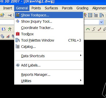
The Toolspace has two tabs:
PROSPECTOR- He's always looking for your Civil 3D Gems!![]()
The Prospector tab is a Window's Explorer type interface that keeps all of your Civil 3D Objects (gems) close at hand.
It is similar to terrain model explorer from Land Desktop- only it is the EVERYTHING explorer.
From the Prospector you can edit object properties, creat new properties, and many more tasks.
When in doubt, right click on something in Prospector!
SETTINGS- How do you make those Civil 3D Gems Shine?!
Every diamond needs a nice setting.
Every Civil 3D object needs a STYLE and LABEL STYLES.
The Settings Tab stores all of your Civil 3D Styles- aka "How Things Look, How things are Labeled, How Commands Run" and other goodies like Pipe Catalogs, etc.
This tab is what your Civil 3D.dwt brings in.
If you don't start from a template, it would be like presenting your fiancee with a gold ore and a raw diamond. The material is there, but it looks like a pile of rocks instead of an engagement ring.
Civil 3D 2007: Finally- A Great Surface from Contour Data
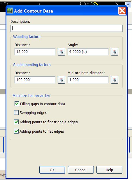
So I had been avoiding learning the 2007 demo for a few weeks because I was working out this really great procedure for dealing with aerial topo. You know how it is so big and hard to manage and you are lucky if your contours are even close to theirs after you build the TIN?
So I thought I was really doing well. After about 10 pages of screen captures, drawing scurbs, Map tools and weed outs, I could get contours that we almost right.
So I sit down and learn the 2007 demo and the FIRST THING IT DOES it show you how there is a tool built in to MATCH CONTOURS THAT YOU ADD TO A SURFACE!
I almost had a heart attack. But it is truly amazing.
Just pick the contours you receive as data (Aerial topo, outside survey, your hand drawn extra contours, etc) and BANG- you've got a great TIN with contours to match.
Add up all the time you spent wrestling with aerial topo and that ALONE is worth installing 07.
It is, however, always best to build a surface from tight data such as points, breaklines, etc. but that is not always possible.
Monday, May 08, 2006
This is adapted and refined from an earlier post. Enjoy.
Keeping Yourself Sane When Inheriting Data from Outside Sources
By Dana Breig Probert, Cadapult LTD.
In today’s world of streamlined and sleek engineering offices, we often find ourselves collaborating with outside firms. In theory, this is a wonderful idea. Let the surveyors specialize in what they do best- surveying. Let the Land Planners work their art and magic. Then, the Architects add their panache. Finally, the Civil Firm gets the data.
Tell me which of the following scenarios best describes what happens once you receive this data:
1.You receive an email with a well formatted drawing, detailed explanations and field notes, a Land XML file and other supporting data. You open the files and understand everything. The data imports smoothly into your version, including breaklines, terrain models, alignments, parcels, etc. You smile and begin happily grading, designing pipes, and whistle while you work.
2.You receive a drawing of an unknown AutoCAD version. After several phone calls and much struggling you manage to open the drawing. Once you open it, it is spaghetti of linework, points, and text. There are about 100 layers with cryptic names. You receive no field notes. You spend about 2 days messing with the data to get it to work in your format. Then, you run into the surveyor at Starbucks and he mentions that he placed the points in the drawing so that North was actually 45 degrees to the left. So now, all of your bearings are wrong and what you thought was state plane was actually an assumed coordinate system referenced off the rodman’s 57 Chevy rear left tire. After crying into your Venti Mocha, you stumble back to the office and spend another 3 days fixing your work only to get a fatal error and an unrecoverable drawing. Which might be a blessing- since you are back to a fresh (?) start.
3.You don’t work with outside firms anymore ever since your health plan stopped covering your emergency visits to your shrink.
There is no perfect way to share data between companies UNLESS you set up project wide standards and make sure everyone collaborating on the project follows them. I would be extremely happy to help you do this with your partners. Email me at dana.probert@cadapult.net and we’ll talk.
The best thing to do: Screen your collaborators. Inform them of your standards. If they need help getting their data into your format, email me and I can work with them to achieve a smoother transition.
Until then- here are some tips to help you when you work with outside firms. This is mostly geared towards outside surveyors, but it is a useful list no matter who you get data from: Architects, Landscape Architects, Planners, Civil Engineers, Structural, etc.
ASK THESE QUESTIONS
1.May I have a copy of your field notes? Field book? Pre-field visit meeting notes?
2.May I have a copy of the deed work? Plats? Historical Documents?
3.May I have a copy of your standard field codes?
4.What did you intend to pick up out in the field?
5.What did you actually pick up? Boundary? Topo? Points?
6.Do you do Field to finish (ie does your linework import with your points)?
7.How did you pick it up? Data collector? What kind? By Hand?
8.What software do you use to process your data?
9.Are elevations valid for topo- for example: Top of Hydrants or Ground Elevation? Wetlands Flags- did you have to hold the rod WAAY over your head to get the location, or is the elevation valid?
10.What Coordinate system- including horizontal and vertical datums? Assumed? State Plane? Other?
DATA PROCESSING
1.What are you sending me? Drawing? What format? ASCII file of points?Land Desktop project? Civil 3D drawing? Land XML? Something else?
2What do you do? Simply dump points? Field to finish linework? Hand linework? Create breaklines? Build TIN? Hand Contour?
3.If you build a TIN- What did you use to build it? Better yet- how can I accurately recreate it?
4.How do you generate TINs? Do you use points? Breaklines? Boundaries? Hand Edit Contours Once Created? Draw Polylines?
5.On a scale of 1 to 10, how good would you say this TIN is? What are its weaknesses? What should I NOT use this TIN for?
DRAWING CLEANLINESS
1.Do you use Layouts/Paperspace or just Model space?
2.Model drawn 1:1?
3.North up? Where is north?
4.Do you have standard layers? May I have your standard layer list?
5.Do you know how to use the layer translator? Can you please translate your layers to our standards before sending?
ONCE YOU GET THE DRAWING IN HOUSE- SCRUB IT!!
1.Save what they send you- read only- someplace safe
2.Open the drawing. Save drawing in YOUR version of AutoCAD with a different name.
3.AUDIT the drawing. Type Y to accept fixing of errors.
4.Explode things they might have sent you as blocks- ie xrefs, contours, etc.
5.Remove unnecessary lines, text, misc garbage
6.Translate layers to YOUR standards
7.Aerial topo or other heavy contours- weed vertices using Land Desktop or Map tools
8.Delete unnecessary objects- blocks you won’t use, their title information, their extra text
9.Use Map Tools for drawing cleanup
10.Decide how to recreate their surface, if any
11.PURGE
12.Change text styles to match your fonts
13.Purge
14.Purge
15.Audit
16.Purge
17.Make North up if not already
18.Transfer Coordinate Systems if not already
19.Make model space 1:1 if not already
NOW- MAKE IT YOURS
1.Once clean, start NEW Civil 3D (or Land Desktop, Map, Whatever) drawing and insert your scrubbed drawing as a block at 0,0,0 explode on import (or better yet, make a wblock of the original drawing, THEN insert the wblock)
2.Recreate surface, if recreating from tin, erase tin lines
3.Once your contours match theirs, erase their contour lines
4.Revisit- what is necessary
5.Create point groups assign styles
6.Create parcels
7.Delete unnecessary linework as it is replaced by Civil 3D Objects
PROTECT YOUR WORK
1.Do Land XML Exports once a day- or at critical junctions especially if you are doing a lot of work like parceling and creating alignments. You can erase yesterdays or keep them if disk space is not an issue, or just keep the ones that you want to remember (ie when the client wants a new lot configuration)
2.Once a day, backup your drawing someplace safe. I.e. if you work on the network, backup to your hard drive or another designated spot. Good File Management is critical to make sure you are not working in your backup file.
3.Have your client or subcontractor call me and I can get you all in the same version and work out procedures for everyone so data goes smoothly
4.Other things to consider: Publish standards for submitting to you. Charge more when data comes in a mess. Encourage clean data and encourage teamwork.
5.Any other ideas? Tips? Pitfalls? Email me dana.probert@cadapult.net and I can add them here.
6.Commit to a version and stick with it. If you, or your partners would like some help finding the best software match, email me and I can help.
The list above won’t guarantee that sharing data will be all happiness and sunshine, but it will give you a starting point to help keep yourself organized and get you to a point where you can start YOUR work as soon as possible.
Thursday, May 04, 2006
UNDER CONSTRUCTION!!
Bear with me... my HTML is fiercely rusty. Amazing how spoiled I got with Front Page. I am trying to get the blog looking good. so the format is a bit weird as I brush up.
Dana
Wednesday, May 03, 2006
We're Taking this show on the road!
2007 Civil and Mapping CAD Clinics
For Engineers, Surveyors, Landscape Architects, and Land Professionals of all Kinds
Come learn about how Civil 3D 2007 and Map 3D 2007 can help you get your job done.
All events are no charge and include breakfast!
All events registration and food at 8:30AM
Speakers 9AM-12PM unless noted otherwise
To register- www.cadapult.net/events.cfm
5/10 Dover Downs
5/12 Holiday Inn Boardwark Atlantic City
5/16 Philadelphia Chamber of Commerce (9:30AM)
5/17 Wilmington Riverfront
5/22 Netherland Inn Strasburg, PA
6/13 Sheraton Great Valley Frazer, PA
We'll have the Civil/Mapping group THE WHOLE TIME so we can cover great industry-specific information!
Detailed Civil/Mapping Agenda:
1. Breakfast and Registration
2. Why Civil 3D? And what the heck is it anyway? Whatever happened to AutoCAD?
3. Life Before Civil 3D and Life After Civil 3D: A Site Plan Study
4. Civil 3D Nuts and Bolts: A demonstration of a sample project
5. Civil 3D Survey Tools- Yes! They are finally integrated.
6. Civil 3D new features-Why install (or upgrade to) 2007? (including discussions of vault and project data sharing)
7. Map 3D and Raster Design- tools every engineer needs to know, plus hard-core mapping including connecting to live sites, thematic mapping and others
8. What's new in AutoCAD? 3D tools, easy visualization and things you may have missed from the last few releases.