It is difficult to dig though all of the material about what is going on with Autodesk's packages for Land Development Professionals, Civil Engineers, Surveyors, Planners, Highway Designers and Landscape Architects.
I will do my best to break it down here in very general, very simplistic terms. Please make sure in additon to what I say here, you also spend a bit of time talking to your local reseller to make sure you have the all the tools you need. After all, these are your hard earned business dollars, you want to make sure you are making a solid decision.
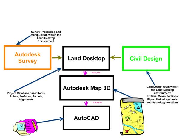
Land Desktop is a program that has been around for a long time. It is a database project based program that adds intelligence to certain objects so that they know to look in the database for their "project" information and/or stores definition data in the database.
For example, a Land Desktop point knows that it corresponds with a certain point number in the project database. The database warehouses the northing, easting and elevation data. An alignment is defined when you tell Land Desktop that a certain collection of vectors are worthy of remembering as an alignment. Though that particular set of vectors doesn't hold a link to the database, the alignment can be recreated as defined from that database information at any time.
Land Desktop menus include: Projects, Points, Terrain, Alignments, Parcels, Lines/Curves, etc.
Land Desktop is built on Map 3D and Map 3D is built on AutoCAD. What this means is that when you open up Land Desktop, you have all of the Map tools and all of the AutoCAD tools.
Autodesk Survey is a tool that works inside Land Desktop (you must have Land Desktop to run Autodesk Survey) that handles survey data manipulation and processing- things like Field to Finish linework, traverse adjustment, fieldbook processing, etc.
Civil Design is a tool that works inside Land Desktop (you must have Land Desktop to run Civil Design). You often don't realize that you have Civil Design. Civil Design includes the menus that you see such as Profiles, Cross Sections, Pipes, Hydrology and Sheet Manager (NOT Sheet Set Manager, which is an AutoCAD tool)
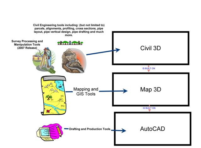
Civil 3D is a model based program. The objects that you create in Civil 3D house their own "project" intellegence, no external database exists to house this intellegence (with exception, and there are ways to share this data in as well- but that is a topic for another day).
For example, a point in Civil 3D holds its own Northing, Easting and Elevation intelligence, it does not have to look externally for that information. Also, if I move that point in my drawing, it automatically really MOVES that point.
The model is dynamic whichs means if I move that point or change that elevation, and that point was referenced in a surface, that surface would also change right away.
Civil 3D is built on Map 3D and Map 3D is built on AutoCAD. What this means is that when you open up Civil 3D, you have all of the Map tools and all of the AutoCAD tools.
Civil 3D tools include: Survey processing (new with the 2007 release), Points, Surfaces, Alignments, Profiles, Corridor Modeling, Cross Sections, Pipe Layout, Pipe Vertical Design, Pipe Drafting, annotation and much more.
Generally speaking, Civil 3D is capable of doing most of the tasks that most folks used Land Desktop + Civil Design for. Functions that are not built in to Civil 3D 2007 that you would find in LDT+CD include: pipe hydraulics, hydrology, sheet manager, and a handful of other things that may or may not be important to you- please make sure you ask your reseller if you have specific concerns about your projects.
Civil 3D has been released 3-4 times so far, depending on where you start counting. There was a 2005 release, a 2006 release, and now 2007.
Civil 3D is positioned to be the baseline platform for Autodesk's civil engineering packages, yet Autodesk realizes that many of us have years and years of Land Desktop projects and we aren't ready to let go of Land Desktop.
So Civil 3D and Land Desktop are being released in paralell (at least for 2007, I am not sure what the future holds).
The bottom line: Civil 3D comes with a companion seat of Land Desktop. You can also still get a companion seat of Civil Design. Use Land Desktop until you are ready to make the switch. There are other articles in my blog and others about strategies to approach this switch.
Vocabulary Clarification:
Land Desktop Companion: Civil 3D comes with a "companion" seat of Land Desktop. It is called the "companion" because your actual license is for Civil 3D, and Land Desktop is its "buddy".
Civil Design Companion: This is a seat of Civil Design that works within your "companion" seat of Land Desktop.
Civil 3D Pro or Civil 3D Professional: This was a bundle of software that included Civil 3D, Land Desktop Companion and Civil Design Companion. Civil 3D Pro in itself is NOT software. It was just a relatively confusing way to say "You needed all three"


3 Comments:
!! Applause, applause !!
A very informative synopsis of the differentiae betwixt all of the "cohorts" in the current Autodesk "game" for the Civil crowd.
Bravo, Dana.
Don Reichle
Nice picture even if your cooridor was ugly...
Why not work with proven technology...such as PowerCivil ??
Get true relational modeling in a stable package and not have to wait while items update
I hope you don't mind but I'm going to present this to our engineers and drafting staff to explain to them exactly what our upgrade from LDD '04 to C3D '07 will entail and what they will have on their computer after the upgrade. Your post just explains it perfectly, thank you thank you thank you!
Post a Comment