Saturday, July 29, 2006
Civil 3D Get RIGHT Back Up on that Horse IMix
Posted by Dana at 8:44:00 PM 1 comments
Friday, July 28, 2006
Warm up your Printer- Civil 3D Tutorials in PDF
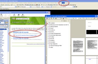
It's a lovely summer Friday night here in God's Country and what am I doing?
A gleeful dance around the ol' Canon Inkjet.
I have to thank my lucky stars that Mr. Probert brought home a box of printer paper from Walmart today because the Civil 3D Tutorials have come to PDF.
If you are like me, reading the tutorials off of the screen while working on them has always been difficult.
Now I can print them out and read them while working.
Or read them anywhere!
Try taking them on the bus! On the plane! In a bubble bath!
Posted by Dana at 10:52:00 PM 0 comments
Thursday, July 27, 2006
How to Corrupt a Civil 3D Drawing in One Easy Step
Want to corrupt a drawing beyond repair?
IGNORE
SITE TOPOLOGY
Ever heard of it? I doubt it.
The Civil 3D Essentials book barely mentions it.
The white paper on Large Subdivision design doesn't even have the WORD topology in it. And has little mention of the Civil 3D "site".
Yet, in order for parcels, alignments, feature lines and grading to work together well, you need to understand how they interact together, what interactions make sense, and how to separate them when necessary. They neither label correctly, nor behave correctly if you get this wrong. If they are really wrong, you will fatal error. If they are particularly bad, they will destroy your drawing. And I mean destroy- not even the jaws of life can get it open at that point.
I live, eat, breathe and sleep Civil 3D, and it wasn't until recently that I truly grasped what exactly was going on here and why it is so important.
My post about Parcel Rules Explained is really just a lesson in keeping parcel topology sound. I spent a little more time talking about Civil 3D "sites" in my post One Approach to Site Geometry .
More and more, I have been able to educate people on the ALIGNMENTS and PARCELS aspect of "site".
So now we are getting good. We are moving past parcels. We are doing feature lines and grading objects.
DID YOU KNOW that grading objects and feature lines ALSO interact with your site geometry?
Meaning: a feature line will bisect a parcel exactly the same way an alignment will if they are on the same site? That a grading object done within a parcel will do the same thing when they are on the same site?
How about this one. Extract a feature line from your corridor, and IT BECOMES THE SAME AS A PARCEL SEGMENT.
So now, our gorgeous site that we worked so hard to keep the alignments and parcels under control is HOSED because of feature lines.
Another thing- let's say you have two feature lines. One representing a ditch CL and one representing another ditch CL that crosses the first. Now, if they are on the same site, they both will not only get a PI at their crossing, but will also often fail to react to the grading tools because they "see" the other feature line.
Just like an alignment, if a feature line curls around itself a little bit, it seems to want to make a parcel. This appears to behave the same way as a "leaky bucket" (See parcel rules explained) and becomes fiercely unstable.
Suddenly yesterday while I was working with a client on a troublesome drawing, it finally hit me like a ton of bricks that over the past year and a half almost every single corrupt drawing that has come my way was very likely a victim of bad site geometry. Even the ones I didn't recognize as parcel or alignment problems.
But until you realize that, you are destined to hose drawings left right and center because it seems to be random.
I have a GIANT stack of work on my desk and a box full of email to sort through, and I would love to talk more about this, and I will. But I couldn't let another day go by without putting something up about this.
Until then, study the Parcel Rules and Site Geometry and keep your geometry clean and separated on different sites.
Posted by Dana at 7:09:00 PM 3 comments
Monday, July 24, 2006
To all of the grown up students out there...
Just a little plea from someone who teaches a lot of classes to a lot of people....
PLEASE PLEASE tell the instructor that you are
...lost
...behind
...feel she is moving too fast
...feel she is moving too slow
...covering subjects you already know
...etc
If you are uncomfortable raising your hand, grab her during the break. Explain what is going on. Maybe she can fix it. Maybe she can't fix it due to time contraints or expectations from the management that ordered the training. But she can try. And she can make a suggestion to management, or arrange for tutorials or record an AVI.
Don't just sit there and say nothing.
I know as an instructor I need to observe the class and make sure things are moving, but I am a human being and I don't speak whine, snicker or grumble, and I certainly don't speak silent.
So everyone out there- SPEAK UP- and let us human beings who are standing before you, vulnerable and occasionally self conscious know that you need help.
It is our job to get you that help!
Posted by Dana at 8:31:00 PM 2 comments
Sunday, July 23, 2006
Saturday, July 22, 2006
Convert your old plot files PLT to DWF
I was with a client yesterday who has years worth of archived submittals in the form of .PLT files.
They are large, unruly, difficult to backup and difficult to view.
We were looking for a way to convert PLT into DWF in the hopes of smaller file size, multiple sheets per file and ease of view.
We googled for a little while, and came up with AcroPlot
There was a free trial, so we downloaded it right then and there.
It worked really well. It did not provide an instant miracle of significantly smaller file size, but it did allow us to build a single DWF from many PLT files, and they came over looking really nice. At the very least, he can now have one DWF with 10 sheets vs 20 PLT files to organize.
This may not be the only solution out there, but it is one that we found worked.
Posted by Dana at 1:15:00 PM 0 comments
Friday, July 21, 2006
Intro to Geographic Data from Penn State World Campus
In my first 30 years of life, (the second began on May 14) there have been a handful of truly memorable learning experiences that truly change the way you see the world. Here are a few.
THIRD SEMESTER CALCULUS
The Tree and the Triple Integral
I make no claim to have been a good student while in engineering school. I had kind of fallen into Civil Engineering by accident, and I wasn't sure exactly what a Civil Engineer did until about 2 years after graduation. So as a student, I was a bit unsure of my future. But that doesn't mean that I didn't learn anything. Au Contraire.
I am horrible at arithmatic. I cannot add, subtract, multiply nor divide. I constantly mix up 8*4 and 9*7 (in fact I just used windows calculator to figure out which numbers I mix up). This is why I loved metric. You just slide the decimal place. It took me a few months to stop doing that once we moved back to the US. (40 FT is NOT 400 INCHES) However, I had serious fun in high school with geometry and trig.
I really kinda dug calculus from the get go, but third semester was the one that stands out.
I remember sitting there in the laundry room in the dorm while I was doing my homework, and looking out the window at a tree. I immediately saw the tree as a f(x) rotated about the Z axis. I could picture it in two dimensions and spun it around to make three.
It was awesome.
I began wondering if everything could be explained in terms of a triple integral. Easy ones- trash cans, pencils, sure, but what about cars, Barbie Dolls, cheesesteaks?
Despite this epiphany, I received a C in the class.
This might help explain my recent obsession with the Playdoh Fun Factory and Corridor Models. They both involve choosing a typical section to extrude and stretch over a series of X,Y,Z variables.
RICH DAD POOR DAD by Robert Kiyosaki
It says: Best Selling Author. NOT Best Writing Author
I read this book as part of the "Give it to Dana, She'll Read Anything" Club during donut Fridays at Stantec. My job was to read a book and give everyone the reader's digest version over donut time (15 mins) on Friday mornings. RICH DAD POOR DAD was number 2 on the list.
Despite the often cumbersome language, grammar problems and misspellings (which HAD to be left in on purpose) I couldn't put the book down. Paradigm Shift may be a buzzword, but it is the only words close to what happened in my brain when I saw his diagrams about Assets vs. Liabilities and Income vs. Expenses.
That book completely changed my approach to life. It is why I drive a beater, live in a hovel, and have my own LLC. It is also why I went to the merchant marine academy and flew a plane in Vietnam...no wait...
GET TO THE POINT... BUT PUT IT ON THE RIGHT GRID
Geographic Data vs. Fortran.. Holes in the Brand Name Engineering Education
While it is quite possible that I was sleeping on the Mason Building couch when they covered the topics of Coordinate Systems, TINs, Projections, Mapping, etc., I find it very strange that I can still write a snippet of Fortran, but until I took the first course in Penn State's GIS Certificate two years ago, I was a complete Geographic Moron.
I took this class in 2004 after I received a contract to do a data layer creation for a local gov't office. They said- "You know GIS?" and I said "Suuuuure". When I got home, I signed up for the class.
In a few months, I learned about projections, coordinate systems, mapping, topography, remote sensing, TINs, GPS, mapping, theming, and many other elements of Geographic Data.
By the end of the class, the fog of mystery that had always hung around me when people started talking about transforming from local to state plane coordinates, and NAD 83 vs NAD 27 had lifted.
When you start taking advantage of all of the free GIS data, raster imagery, DEMs, etc. out there, unless you have a really good grip on what you are importing, why it is important and most critically- how to transform it to come in to your drawing at the right place. (noting that Move/Scale/Rotate is often not solution due to re-transformation onto a different projection in addition to changing location).
As a direct result of this newfound knowledge, I could not peel an orange for over a year without taking the skin and tearing it into a Mercator projection.
I can not count how many times I have gotten tech support calls from otherwise incredibly sharp engineers who can't get Map data to come in right, and when I ask about coordinate systems they either look at me blankly or give me an incomplete answer- such as "Latitute Longitude" or "State Plane".
The important question it not "How do I change Lat Long to Northing and Easting", but WHICH lat long to WHICH Northing and Easting.
In addition to demystifying coordinate systems, I could finally explain how a TIN is built and how to tell if it needed adjustment.
This let to an interesting incident at Bootcamp in Dallas where Beth and I attempted to teach the architects from our office how a TIN is built using cherry tomatoes and kebob skewers. They weren't impressed.
I honestly do not know how I would possibly function in today's GIS driven Civil world without this class.
Go take it. It is an online class- open to the world. I wish I had taken it sooner.
Posted by Dana at 10:31:00 PM 0 comments
I FINALLY found you KEVIN ROSE!
I measure my life in two epochs.
Not BEFORE KIDS and AFTER KIDS
but TECHTV and G4
Back before there was Civil 3D.... Back before all of us CAD groupies had Techie Idols like Anthony, James, Nick, Mark, Peter and of course "Dan and Dave"...
There were a bunch of twenty something college dropouts with a big basket of spare motherboards, airwalks and lovingly dishelved hair who came into my living room every night at 7PM and taught me about NewEgg, Firefox and how to Overclock a Toothbrush.
The Screen Savers! Late Gen X Computer Super Heros.
They made the term "LAN Party" a part of my everyday vocabulary.
They brought a partion to my hard drive and a smile to my face.
They winked when they mentioned Napster, they found all the cool websites.
They blogged before blogs were cool.
Their studio spartan, they stood the whole show. I think of them every time I have a demo that doesn't work or a fatal error during a class, because half the time their stuff didn't work.
Kevin and Alex of the Screen Savers were just plain cool. I liked them. I felt like they were my friends. We had just moved to a new town and knew nobody- so Kevin and Alex were our pals.
I secretly dreamed about being invited to the LAN parties, and *almost* text-ed in twice.
Then something weird happened. The studio got dark, the couches got plush. Alex was gone and Kevin was locked in some sort of sidekick room while a corny, but theoretically more "Cool" Kevin became the host, and mousey little Sarah who wouldn't know HTML from LandXML suddenly became the star of the show.
Then, the ultimate insult- the name changed from the Screen Savers to Attack of the Show.
We stopped watching.
Today, while visiting a client, I found him. I FOUND KEVIN ROSE. I don't know how I lost track of him, and I must say- I like him even more now.
If you loved the screen savers, or if just like hanging out with dorks- check out the Podcasts and Video Podcasts for Kevin's new show DIGGNATION.
It is eveything TechTV used to be- only better- cause there is cursing and beer. And Kevin had the good sense to dump that pseudo-geek, Sarah.
http://www.diggnation.org/
Posted by Dana at 5:01:00 PM 2 comments
Help the C3Diva- Need a customization or ideas for better Civil 3D to Microstation Conversion
I have had decent success getting Civil 3D dwgs into Microstation with Inroads.
However, there is always work to be done with hatches, linetypes, text.
Here is what I am currently doing:
Export LandXML of entire Civil 3D dwg/project
Export Civil 3D.dwg to Acad.dwg
Cleanup Acad.dwg
Run layer translator that we made (changes NCS layer names into the local DOT level numbers/colors)
Export through Map>tools>export to .dgn
Open .dgn in InRoads/Microstation
Import LandXML
Then, the Microstation people have, say 85% useable information.
But they need a lot of cleanup
Does anyone have a customization to assist with this? Or even just some tips to prepare blocks/text for export, or easy ways to recreate on the .dgn side? Or swap out?
Consider that we have full and matching cogo libraries on either side. E.G.- I have a HYDRANT cell in Microstation, and a matching HYDRANT block in Civil 3D/AutoCAD.
My goal is that my clients that work with DOTs will be able to do most, if not all, of their design in C3D.
Then, we will have a great way to get things looking right in Bentley without much pain.
They will always want to open in Microstation for the final prep and check, but I want to make it easy.
And all of this is just model space- the design in this case is the only thing that matters (not sheets.layouts, etc) (but tips on those are welcome, too)
I will pay in money or fresh vegetables.
Posted by Dana at 1:32:00 AM 1 comments
Tuesday, July 18, 2006
Mr. Probert is FAMOUS

Check out the new cover dude for www.deldot.org
White shirt, tan hat, using a shovel!!
Posted by Dana at 11:29:00 PM 0 comments
Collaboration Seminar for State and Local Government in Dover, DE
Collaboration and Project Management Seminar
Especially for State and Local Government and their Consultants
Autodesk Buzzsaw
Wednesday, August 23, 2006
8:30AM – 11:30AM
Dover Downs Hotel and Conference Center
No Charge
RSVP 1-800-332-9961 ex 10 by August 14, 2006
AGENDA
8:30AM - 9:30AM Registration and Full Breakfast
9AM -10AM Presentation of Project Management and Collaboration Solutions
10AM - 10:15AM Break
10:30AM-11:30AM Q&A, Roundtable discussion
Consider these questions… and consider taking a few hours out of your morning on August 23 to learn about strategies for eliminating frustrations, keeping budgets under control and ensuring that “everyone has the current version”.
§ How many construction permits did your permitting department issue last year?
§ How many people do you have working to check plans and issue permits? Do they have time to sleep?
§ How long does it take a typical construction project to receive approval? Are you spinning your wheels and bogged down?
§ How does your current permitting process work? Would you like to make it less complicated?
§ What problems do you encounter with your current permit process?
§ How does your plan check process deal with checking to make sure city/county revisions are completed? Do your comments contradict other review agencies?
§ What page format do you require for construction permits now? (Example: 11”x17” or 24”x36”) How are you storing all of these?
§ Do you have a process for managing capital improvement projects? How easy is this to manage?
§ How do you manage design data on your capital improvement projects?
§ How are drawings exchanged between your architects & engineers?
§ Are you familiar with the DWF format? Would you like to learn how it can help?
§ What is your bidding process for capital improvement projects? How much man power does it take?
§ How many bid/bid packages do you send out each year? How much paper does that use? How easy is it to manage?
Looking forward to meeting you all!
Posted by Dana at 9:42:00 PM 0 comments
DELAWARE AUTODESK USERS GROUP MEETING
The next DAUG meeting will be:
Wednesday, July 26 at 5:30 pm
Tetra Tech office (off 273, Christiana, DE).
TOPIC: Autodesk CUI (Customize User Interface)
As we rotate topics, this will serve as the “General Autodesk” portion.
This intermediate-level discussion group will focus on how different companies have implemented (or coped with) the new CUI interface. Please come with ideas, debate, and experiences.
Introductory level questions will be fine, too, just be aware that we’ll be a little fast paced.
Hosted by: Casey Grabowski
Please bring $5 for pizza and beverage.
Directions: From I-95, take the Rt. 273 exit towards Christiana. At the 2nd light, make a left. You will see our big glass building on the corner.
Make the first right as to wrap around the construction (Main Street), continue past the construction, and turn right to enter into the Tetra Tech parking lot.
You can park up front. We’ll be on the 4th floor.
Please RSVP so we know how much food to order, or let us know if you would like an alternate food.
RSVP to casey.grabowski-NOSPAM-@tetratech.com (remove the -NOSPAM- in your email program)
Posted by Dana at 4:48:00 PM 1 comments
Monday, July 17, 2006
TAMING THE CIVIL 3DEMON (or MAP 3DEMON): FATAL ERROR OF THE DAY
 FATAL ERROR: Unhandled e0434f4dh Exception at 7c81eb33h
If you get this error upon starting Map or Civil 3D or anything else it is probably due to your .NET not working properly. For full details please see:
http://usa.autodesk.com/adsk/servlet/ps/item?siteID=123112&id=7281975&linkID=2475323
Posted by Dana at 6:30:00 PM 1 comments
Sunday, July 16, 2006
Civil 3Delicious: Green with Envy Milkshake
Not only is this milkshake super yummy (I just had one a few minutes ago) but it keeps your skin smooth, your brain sharp and makes people stare. Nobody understands a Green Milkshake. Sounds weird, but I PROMISE this ROCKS.
All of your buddies who are stuck in static Land Desktop world are already Green with Envy that you can use Civil 3D so well, now they will be jealous of your beverage.
GREEN WITH ENVY MILKSHAKE
1 avocado
1 cup milk (more if too thick)
3 tablespoons sugar
2 scoops vanilla ice cream
Add ingredients to blender, blend until smooth.
GREEN WITH ENVY HEALTH SHAKE
1 avocado
1 cup skim milk or soy milk (more if too thick)
3 tablespoons splenda
1 carton fat free vanilla yogurt (throw in freezer for a half hour before making) or 2 scoops frozen yogurt/ice milk or similar
Add ingredients to blender, blend until smooth.
Posted by Dana at 11:52:00 PM 0 comments
Civil 3D: Build a Surface from Points, Proximity Polylines and Boundary
This is what I hope to be the first in a long line of Civil 3D Rocks Helpcasts.
This is probably the world's worst AVI, but bear with me, because it is my first! There is no sound (my microphone is bad- I am getting a new one) and no annotation- but I wanted to test everything out.
The quality is kind of poor through You Tube. I will be looking for another solution...
This AVI shows you, in very simple terms, how to build a surface from point groups, how to add a proximity polyline as a breakline, how to add a boundary. It also shows some really simple dynamic surface editing, and some really simple ways to have a look at your surface in 3D.
Please test it and let me know if it works for you! Since this is infinitely easier and more fun than taking miles of screen captures, in the future I will probably do more Civil3D Rocks Helpcasts!
TRYING AGAIN>>> COMING SOON
Posted by Dana at 9:58:00 PM 2 comments
Firefox
It has recently come to my attention (while using my husband's computer) that this blog looks like junk in Firefox. I will work on it eventually. Sorry to firefox users! the sidebar comes in weird at the bottom. I guess my sloppy HTML finally caught up with me.
Posted by Dana at 9:14:00 PM 1 comments
Friday, July 14, 2006
RSS
I went to feedburner and did their thing. This is all new to me- if this doesn't work the way you expect- please let me know
Posted by Dana at 10:42:00 PM 2 comments
Thursday, July 13, 2006
Taming the Civil 3Demon: FATAL ERROR of the Day

Today's family of fatal errors has to do with expressions. It is easy to avoid once you know what is causing them, and the "powers that be" are aware of this problem and hope to have a solution soon.
If you get any of the following types of errors when creating parcels that use an expression in their area label style:
FATAL ERROR: Unhandled c0000090h Exception at dd3720eh
FATAL ERROR: Unhandled c0000090h Exception at de1720eh
FATAL ERROR: Unhandled c0000090h Exception at ddc720eh
Just change the area label style to one with no expression, then lay out your parcels, then later change the labels to your style with the expression. To be safe, also save a copy of your drawing or template without that expression style.
This isn't stopping me from using expressions, just stopping me from having my label that includes expressions pop in by default.
Posted by Dana at 11:11:00 AM 0 comments
Wednesday, July 12, 2006
Addendum to Almost Instant Comma
There are a few things you need to keep in mind when using the comma work around for Civil 3D 2007. (gets a comma into your label styles)
For starters- Here is the link to the original post Almost Instant Comma's Gonna Get You!
Civil 3D can "track" up to 8 decimal points. This means for area calcs, line lengths, etc. it can hold 8 decimal points. Your label styles can label up to as many decimal points as the drawing is "tracking". I pretty much universally recommend cranking the ambient decimal points up to 8, then using your label styles to pick how many you want labeled and how to handle the rounding.
Here are where those settings are stored:
Ambient Settings can be universally set for the whole drawing under drawing settings. Toolspace>Settings Tab Right click on drawing name.
For your label styles, you can choose to label up to that ambient precision setting. If you choose less, it wants to know how you want it to round. For most cases, you might want round normal. For the comma case to work right, you want TRUNCATE.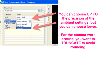
Posted by Dana at 10:16:00 AM 1 comments
Tuesday, July 11, 2006
Favorite Drives
This post has turned out to be long and maybe boring. TOO BAD. My blog :)
I am enjoying a rare night on the road in York, PA. York is a small city with heaps of charm and broad appeal- reminiscent of Old New Castle, DE or even a scaled down, low key Rittenhouse Square (Philadelphia) Lots of walk ups with brick fronts, colonial colors, wrought iron window boxes and architectural detail. Market Street has extra wide sidewalks with shady trees and cafes. Walking around today I said, "WHY don't I live here?"
The drive up from the Eastern Shore was unexpectedly pleasant. I've added I-83 from Baltimore to York on my list of all time enjoyable drives.
There are certain roads that just are pleasant. I used to think that those pleasant feelings were due to intangibles- and sometimes they are- good company, good times, good weather- but other times what we think are intangible are actually "designable" things like ROW width, shade, driver expectancy, etc.
Here is a list of some of my favorite drives and why they appeal. Some may surprise you!
I-83 From Baltimore to York
After the drag of the Baltimore Loop, suddenly I was propelled onto a seemingly normal interstate. But something was different- wide, tree packed median, trees along the ROW. Surprisingly rural and rolling terrain on either side. No traffic this AM during rush hour, and destination YORK, my new favorite small city to visit a favorite client.
PA 73 from Center Point, West to Zern's Market and Beyond
Many people hate this stretch of road for its traffic lights, relatively low speed limit, twists, turns and small towns. I like it. It goes through some typical SE PA small towns, it usually has a ton of shade. The ROW is rather narrow, which makes it more comfortable for a country drive and less pressure to speed. Plus, Zern's was a favorite spot to go when I was a kid, and as a teenager we could get those gas station attendant shirts at the flea market with names like "Earl" and "Jeb" on the name-oval. Further west it goes through some of the most special colonial farmland and the quaint antique-ville of Boyertown.
PA73 from Center Point, East to the "Bent Elbow"
Heading the other way creates similar looks of question from many friends- they never thought about it. Same relatively narrow ROW. More mature trees, no passing allowed and little pressure to be passed. Along with its paralell, Morris Road, a drive alive with foliage in October.
PA/DE 896 from Lancaster to Newark
Once a year, we do a seminar in Lancaster. The drive back to Newark is probably my favorite drive of all time. The first time I did it, I couldn't stop marveling at the fabulous gardens that the farmhouses had. I kept thinking, "WOW. You could LIVE out of that garden. It is huge and not a weed to be seen" Then, I saw a family of Amish children run through the field and I remembered where I was and realized that they do LIVE out of that garden. The ROW is VERY narrow, the road has twists, hills and turns, but they are predictable, well marked and not "blind". While some folks get flustered with the buggy traffic, I find it refreshing. There is little hustle and bustle between Lancaster and Newark, so what's the hurry?
Almost Any Edmonton City Street
Edmonton Streets are almost universally lined with tall and aged elm trees. Alberta has the world's largest collection of standing elms which so far have avoided dutch elm disease (though there are other threats). The canopy is VERY high giving a feeling of intense space, yet cozy canopy. Edmonton streets run on a near perfect grid and are extremely cartesian. The street and avenues are almost all named by number and that number is built into the address. So 10160 - 112 Street would be 112 Street near 101 Ave. You never need directions, just an address and a square mind. (Though sometimes the River gets in the way)
Garden State Parkway from AC Expressway South
Say what you will about New Jersey and the Jersey Shore, but unless you drive the GSP on a Sunday night or the forth of July, it is a dream road. All of the shore towns are on the barrier island, so you have to turn off the GSP and go over the bridge, which means you don't cut through the middle of any towns. One side is Route 9 with its rural-ish residental, the Cape May Zoo, etc. On the other side is the wide marsh. There are trees in the median, great signagle, predictable exits and easy access to Route 9 for a paralell alternative.
Trans Canada Highway 16 from Edmonton to Jasper and on to Vancouver via 5
Great little crazy fun country towns like Entwhistle, Edson, Hinton... Avoiding the bighorns in the road in Jasper with its icy crystal blue waters and grey-white mountains. Little roadside commercial makes for a pleasant drive. On the BC side, there are pull-off rest stops that I have napped at often and always felt safe, signs that politely remind you to "Please get gas, or else you will run out".
Highway 50 from Annapolis to Ocean City, MD and 404 to Georgetown, DE
The route that the Baltimore/DC crowd takes to the beach is much more pleasant than the drive PA yankees take to the same beaches. Where Route 1 below Milford is awful, 404 and 50 are really kinda nice. Maybe it is the sales tax in MD. 404 is only 2 lanes most places but the roadside commerical is minimal. Perhaps due to zoning, perhaps just no demand. I can't be sure on the MD side. The signage is great and SHA signs politely remind you to turn your lights on while the rumble strips in the center keep you between the ditches. Route 50 from Salisbury to Ocean City has a broad forested median, and semi limited access. Commerical areas along its banks usually have secondary road access as opposed to direct Route 50 access. It goes through the same type of landscape as most of the awful chunks of Route 1. Route 1 could have been this nice, maybe not as wide, but just as nice.
LEAST FAVORITE DRIVES
Defford Road, Worcester, PA- The street I grew up on
GIANT ROW with large lanes and rolled curb make for a motor speedway subdivision. Throw in unpruned pinoaks as boulevard trees with their absolute lack of welcoming canopy (even triangular shape) and you have the nightmare that is the 1980's tract development. It feels like Dover Speedway to me when I drive through with the pinoaks as the banking walls.
DE Route 1 from Milford to Ocean City, MD and its paralell 113 from Milford to Berlin, MD
These roads were two lane roads that were dualized. The original road had small time highway commercial. The dualization brought more highway commerical. The plan backfired. They are now talking about a bypass for this original bypass. It is a nightmare of traffic lights, "right-in right-out" entrances and poor zoning/master planning all around.
Both roads divide towns with unwalkable, dangerous 4-6 lanes of traffic. Route 1 is a hazard to nesting sea turtles and bike riding tourists.
There is not a tree in sight. I have a Toyota Echo with no airconditioning. Just thinking about Route 1 makes me sweat. I absolutely avoid the area at all costs. If I do go, I chart an elborate route to ensure I never have to make a left turn, which usually also means a U-Turn. Even with light traffic it makes me tense, but more often it just makes me sad since it they had done it well (along the lines of Route 50) or even the GSP it could be quite magical.
Route 309 from Montgomeryville PA north to Allentown... Route 309 Ambler to Philadelphia. DUDE, all of Route 309
Five point intersections with no clear pattern, extremly narrow lanes, jersey barriers, stop-merging, hard and fast exits, disappearing lanes, battered pavement, unexpected traffic lights and BREAKNECK speed. No wonder everyone is angry on 309.
Roosevelt Boulevard, Philadelphia
I cannot even express how scary this road is. Four to six "express" lanes on the inside. Two one way (?) lanes on the local "outside". Exits out of nowhere. Crazy drivers. Confusing lights, unclear one ways... I am lucky I ever went to visit my grandmother without a major accident. I think it has trees, but I was always so busy looking for a sign and cutting someone off.
Road around City Hall, Philadelphia
The purgatory of roads. Keep going around, you might figure out what lane you need to be in. And don't worry- the pedestrians won't cross against the light.
Vine Street Expressway
Every single time- I wind up in Jersey. I always miss my exit. I have almost merged into people about 4000 times. Then, after killing myself to move 3 lanes in 100 yards, I miss my exit and wind up in Jersey. Which isn't so bad, because the Ben Franklin is one of my favorite bridges.
Posted by Dana at 8:36:00 PM 0 comments
Monday, July 10, 2006
Pipe Structures on a Tool Palette?
For my post
Civil 3D Nuts and Bolts: New Pipe Network Goodies for 2007
I received this comment
Mark said...
Do you know how to create regular pipe structures like DIs or head walls and save them in a tool pallet
Thank you for your comment, Mark!
I'd like to start off by referencing a post from the other day:
Showing and Labeling Pipe Structures...
It doesn't specifically answer your question, but it does have screen captures for the three ways you can show structures in profile, which also correspond to three ways you can show structures in plan.
1) Display the Model itself: The model is a 3D parameter part. In plan, it will see the top, in profile it will see the side. This shows a mesh representation. Most people don't like it.
2)Display the outline of the model: as above, only doesn't show the mesh
3)Display the block of your choice: Most people like this one. For MH in plan, you can pick your "Circle with an S" for CBs in profile, you can pick your regular old block from LDT if you like. ANY block can represent a structure. It just has to be in the drawing.
Either way, the way these structures look is controlled by structure style.
You don't have to build a toolpalette for them, because that is what your parts lists do for you. Build a parts list that has your common storm sewer parts (like headwalls, etc.) and map which style you want C3D to use for those parts. So HEADWALL=HEADWALL BLOCK ON X-LAYER.
In fact, building a toolpalette for structures is meaningless, since you insert structures from your parts list as you make the network.
It seems like pipes and structures would behave like road parts since they are both catalogs, but they are not the same. Subassemblies can go on a TP, but pipe network parts cannot.
Clear as mud? :)
I gotta get up early and do a long drive, but tomorrow night I am staying out on the road so I will have some time to post screen captures. Mark, feel free to comment if this didn't get you on the right track.
Posted by Dana at 8:52:00 PM 0 comments
Sunday, July 09, 2006
Labeling Elevation at Any Point Along a Profile and At Regular Intervals Along a Profile
This isn't as "sexy" as I would like it to be, but it is pretty darned good for labeling any point along a profile with its elevation.
The first one I will show you is "user chosen" labels. Meaning, you have a special location you want to highlight and show the elevation.
The second one I will show is elevations at regular intervals and horizontal geometry points. Perhaps you are required to show an elevation (in profile) at PC, PT, and every 100 ft station.
This works in Civil 3D 2007. In Civil 3D 2006, I am not 100% sure you can do the Prof1/Prof2 thing I show below, but you can make a similar label style and it just won't be quite as automatic. See my post about pipe crossings for how I would handle it in 2006.
Civil 3D Vocabulary review
PROFILE = The line representing ground. Examples: Sampled EG, Finished Grade by Layout, Sampled Subsurface, etc.
PROFILE VIEW = The grid, the Title, etc.
A profile is drawn on a profile view. If Civil 3D asks you to choose a profile, it wants you to pick that line. If Civil 3D asks you to choose a profile view, choose anywhere on the grid.
USER CHOSEN PROFILE ELEVATION LABELS
You have an FG profile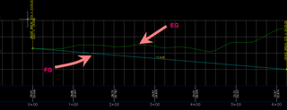
Make a PROFILE VIEW label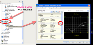
That calls out whatever you want (station, etc) AND calls out PROFILE 2 Elevation. This means that no matter where you stick it elevation wise on the profile view (grid) it still reads the elevation of PROFILE 2 at that station. We will tell it what we think profile 2 is later.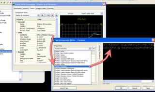
Add PROFILE VIEW Labels
It will ask you to choose the profile view, then ask for a station. You can physically pick the station or type it in. For elevation, it doesn't matter. Just pick where you want the label to live.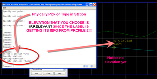
Now we need to tell it what we want PROFILE 2 to be. It leaves elevation blank for a sec.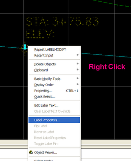
Pick- Right Click- Assign Profiles 1 and 2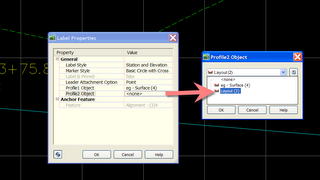
TADA! You can make this as pretty as you want. instead of the marker, you could build lines, etc. into the label style, or have no marker or a picture of your dog, OR WHATEVER. Almost anything is possible cosmetically in the world of Civil 3D styles.
Now, COPY this label and stick it everywhere. That way you don't have to reset what PROF1 and PROF2 are.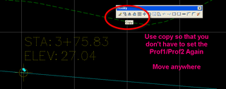
Beautiful
Move your profile. Notice the labels don't move, but if you REGENALL- the LABELS WILL UPDATE WITH THE NEW ELEVATIONS OF PROF2. HURRAY! If you label style is composed in a way that doesn't make it obvious for minor moves, you could get away with never touching those labels again.
How about a similar label at regular intervals?
This one is a PROFILE label. Make a major station label that includes elevation. Also note you can add elevation to the geometry point style as well for PC, PT, and other horizontal geometry points that you need to highlight in profile.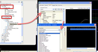
Add it to a label set for use in future profiles.
OR, Right click on your profile and Edit Labels
To add to profiles already in your drawing.
TADA. These will move with and update with your profile with no problem.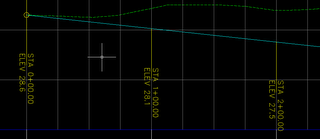
There is a lot more we can do with this... Notice all of the different things we can harvest off of a profile or an alignment for the profile labeling... throw in references and expressions and there are probably millions of labels we could compose. Let me know if there is one out there that is stumping you!
Posted by Dana at 2:08:00 AM 1 comments
Saturday, July 08, 2006
Will you be in New York over the next few days?
So a little while ago I told you that I went to high school with Eric Wareheim from Tom Goes to the Mayor.
Well, I have another talented friend to plug.
He is Rusty Ward, a stand up comedian and a stand up guy. I have known him longer than I can remember- he was a fellow member of the swim team since birth. I can only picture him with bloodshot eyes, frizzled chlorine hair and a distinctive bleach-like odor. I saw him perform last year in Philly, and he was hilarious. And he smelled good, too. I wish I could see him more often.
More information can be found at www.rustyward.com. He also has a myspace profile with a ton of information .
SATURDAY, JULY 8
Ron Poole's Poole Party
Don't Tell Mama
343 W46 StNY NY
8:30pm
TUESDAY, JULY 11
The taping of Rusty's debut CD
Don't Tell Mama
343 W46 StNY NY
9pm
WEDNESDAY, JULY 12
The taping of Rusty's debut CD
Don't Tell Mama
343 W46 StNY NY
9pm
Posted by Dana at 8:18:00 PM 0 comments
Friday, July 07, 2006
Why aren't you a member of the Urban Land Insitute?
My obsession with ULI began when I was 22 and working in Edmonton. The big cheeses would mysteriously show up for work wearing ties and ironed slacks one day a month. Then, instead of playing hockey or curling during lunch, they would head down to the Fancy Pants Skating and Eating Club. What happened during those gourmet lunches anyway?
When I finally was able to go myself, I was in love. A whole hour to eat (the Fancy Pants club has great Nanaimo Bars) and learn about recent trends in land development. Does it get any better than that?
Stantec also had an excellent, but rarely used, reading room downstairs. I would go down there on slow afternoons and thumb through Urban Land, the official magazine of ULI.
What is ULI really about?
Who should join?
I think every single engineer or designer who does anything with Land Development should be a member.
Locally- you can attend meetings, breakfasts, networking, etc. and meet developers, legal professionals and others in your area. Learn about local projects and issues. Build your career.
Nationally- even if you just flip through the magazine you realize that other people in different parts of the US and Canada are dealing with the same issues as you are.
Think of how many of us on the engineering side just hammer through our work and don't take the time to market ourselves, to learn what is really going through our client's minds... this is our chance to differentiate ourselves.
For more benefits click here
WHO ELSE? Lawyers, Architects, Interior Designers, Landscape Architects, Government Employees, and ESPECIALLY STUDENTS.
What an edge students have when they mix and mingle with actual movers and shakers.
What does it cost?
There is no excuse if you are a student or under the age of 35.
There are special fees for those youngsters (or oldsters if you have student ID) that range from $75-$175 per year and includes the subscription to Urban Land, book discounts, etc.
There are various other types of memberships- one for everyone.
To join and learn more- go to: ULI Membership Application and if you do decide to join, please mention me: Dana Probert. I think I get a free t-shirt or something. But more importantly- YOU AND ME NOW BELONG TO THE SAME COOL CLUB!
Some recent and upcoming events in my region to give you an idea of what happens locally:
http://philadelphia.uli.org
ULI Philadelphia Fourth Friday Breakfast
The Pyramid Club, 1735 Market Street, 52nd Floor, center city
Philadelphia
ULI Philadelphia Young Leaders Roundtable - Waterfront Development
Fairmount Water Works Interpretive Center, 640 Waterworks Drive, Philadelphia
ULI Philadelphia Happy Hour
20 Manning, 261 South 20th Street, Philadelphia
ULI Philadelphia Annual Sponsor Appreciation Breakfast
ULI Philadelphia Major Urban Forum TBD
The Union League, Philadelphia
ULI Fall Meeting
Denver Convention Center
Posted by Dana at 11:15:00 PM 0 comments
Land Desktop 2007 Service Pack is HERE
For those of you who know me, you know I have been holding back my words regarding Land Desktop 2007 here on this blog.
Basically, there were problems.
BIG problems with Land Desktop 2007. I am being nice.
I would say more, but I know my friends (the good people in Manchester) read my blog when the mood strikes and I don't want to discount their hard work. Because I do appreciate what they do. I mean it.
Perhaps I can finally take the Land Desktop 2007 install DVD out of the trash, since SERVICE PACK ONE IS HERE.
Go get it at:
http://usa.autodesk.com/adsk/servlet/ps/dl/index?siteID=123112&id=2334435&linkID=2475345
The big news about this is that now those of you who have been putting off using Civil 3D 2007 because you knew your ongoing LDT projects would suffer should be in good shape.
Perhaps, give the LDT service pack a few weeks to digest, then install.
Here is what it says it will fix: (I quote from the README)
Autodesk Land Desktop 2007 Resolved Issues
Grading
Editing slope tags no longer causes grading lines to be removed.
Labels
Attempting to grip edit a curve whose label exists on a locked layer no longer causes the program to terminate unexpectedly.
Parcels
An issue with breaking parcel lines using the Break Lines\Curves command has been resolved.
Points
The program no longer terminates unexpectedly when listing multiple point groups using the List Points dialog box.
When importing points from a .csv file, the Format Manager (Points > Import\Export points > Format Manager) now handles information in user-defined fields as expected.
An issue with exporting points to a delimited file has been resolved. The program no longer adds a space after every delimiter in the point file.
Creating points by selecting grid coordinates on a surface no longer creates the points in the opposite quadrant.
An issue with the Format Manager Point File Format dialog box displaying invalid characters has been resolved.
Projects
An issue with changing the project path while attempting to open a Land Desktop project has been resolved. When you attempt to open a Land Desktop project, browing to select a new project path location no longer causes the program to terminate unexpectedly.
Terrain Model Explorer
The program no longer terminates unexpectedly when a new text style is selected using the Contour Style Manager's Text Style tab.
An issue with not being able to set new surfaces as current surface has been resolved.
An issue with calculating grid volumes has been resolved. Calculating grid volumes now displays accurate results.
An issue with the Select Surface dialog box displaying after adding contour data to an unbuilt surface has been resolved. Now the Contour Weeding dialog box displays instead of the Select Surface dialog box.
An issue with the Create Surface dialog box displaying after invoking the Add Breakline commands has been resolved. The Create Surface dialog box no longer displays after invoking the Add Breakline command.
An issue with adding a breakline to a newly created surface has been resolved.
An issue with closing a newly created surface has been resolved.
Posted by Dana at 10:40:00 PM 0 comments
Handle the Bag: Cul-de-Sacs and Parcels

How do you do parcels around a cul-de-sac?
This is a quite common question. I used to get bombarded during those notoriously straightforward straight road demos with cries of "BUT THAT ISN'T REAL. WE DO A LOT OF CUL DE SACS" followed by "I hate Civil 3D" and "Civil 3D Sucks".
Well... I do cul de sacs, elbows and other weirdness with Civil 3D parcels all the time. This is just a way that I have found works.
There are many other Autocad and Civil 3D tools that can be combined to make a good cul de sac.
This works in both Civil 3D 2006 and 2007. Don't forget The Parcel Rules .
THE PARCEL TOOLKIT
There are a bunch of AutoCAD commands I like handy when doing a site plan. So I made a Tool Palette for them. Making a custom tool palette is super easy. I am a customization MORON and I can handle this.
If you aren't familiar with toolpalettes, they are SO EASY it hurts.
There is a pdf paper in the Files Area of the Cadapult_Civil Yahoo Group that you can download that will take you throught making a custom toolpalette. Or check out HELP or the New Features Workshop under HELP.
You have to be a Cadapult_Civil Member to get that paper, but everyone is welcome to join. You just need a yahoo login. http://groups.yahoo.com/group/cadapult_civil
REMEMBER- ANY CAPTURE CAN BE ENLARGED BY CLICKING ON IT!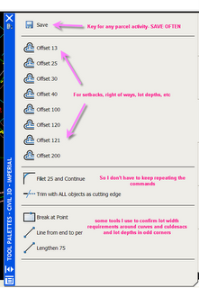
Yes, there is a ROW parcel tool under Parcels Menu. But I don't like it. It works OK for simple stuff, but it is too hard to edit the result. I like to make my ROW and Back of Lot target parcels from polylines.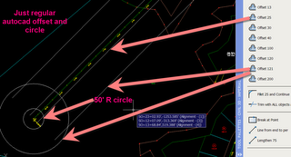
Use regular offset to offset your aligment. The resulting offset lines are polylines.
I make a circle for my culdesac.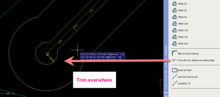
Fillet and trim as necessary around Cul De Sac and intersections. You have to explode the polylines in order to fillet to circle.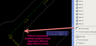
I like to join all the lines to prevent leaky buckets. It also gives me a chance to erase the whole ROW at once later if I want.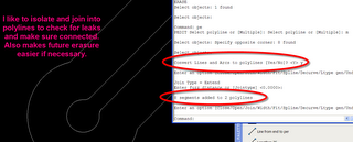
Once they are closed and tight, define them as a parcel.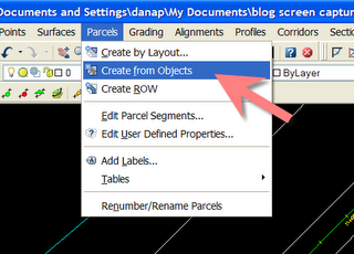
Here is my starting point. I leave the back of lot target rounded for now.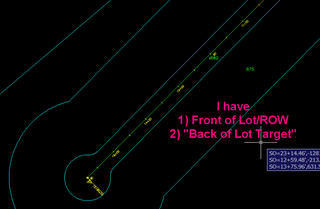
I like to make perfectly sized lots along the first stretch.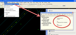
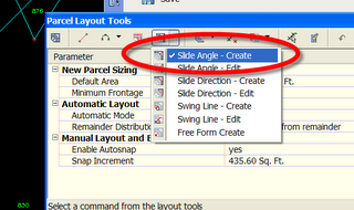
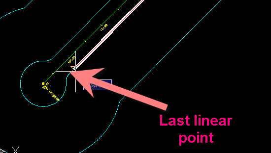
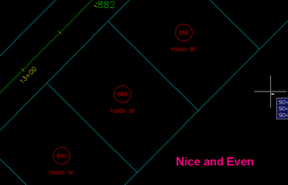
Then, since my lot width is measured from the building restriction line (40 ft in this case) I offset my ROW with a little guideline. You can change the frontage in the parcel layout tools to a lower frontage number if you know what works.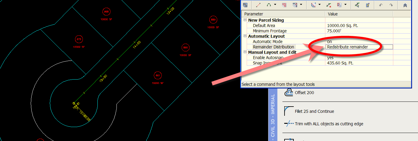
There are a few ways to confirm and get your frontage. This is just the way I am doing it now. Other ideas include making a BRL parcel and a BRL site, then laying your parcels out there with min. frontage and using that result as a guide.
I like to break my guideline at point, then use the lengthen command (which also shortens BTW) to see where 75' is.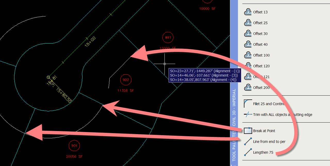
Then I grip edit my attached parcel segment.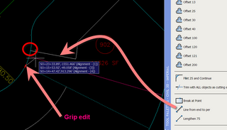
If the width is good, but the lot is too small, I can add another segment.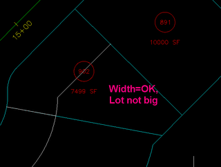
And erase the perpendicular to ROW segment. Using the parcel edit erase button, I can erase one segment at a time.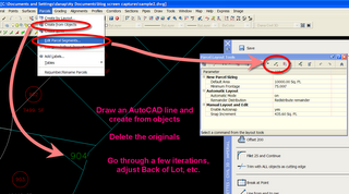
To square up the rears when I am done, I draw a new segment (or acad line then create from objects) then erase the arc using the parcel edit tools.
After a few iterations and adjustments, I wind up with this:
Posted by Dana at 5:34:00 PM 8 comments
The Lone Wolf's Guide to Learning Map 3D (remember Civil 3D and Land Desktop are built on Map!)
 Civil 3D and Land Desktop are both built on Map, which means you have access to the Map GIS tools (and more) inside both of those programs. This is a horn I toot A LOT- and worth tooting again.
IF YOU HAVE CIVIL 3D OR LAND DESKTOP OR MAP in your office YOU HAVE A GREAT GIS PACKAGE! Most people don't know that. You need to know that!
Take advantage of this list even if you have taken, or plan to take a Map 3D 101 Class, go through each item of this list to prepare yourself so that you can really get your money's worth.
Your boss is more likely to send the whole gang to training if s/he sees the benefits of what you were able to pick up on your own.
Two Extremely Basic Things YOU NEED to learn (if nothing else)
1) IMPORT ESRI FILES AS POLYLINES TO THE PROPER COORDINATES All of that free GIS vector data is out there. Why are you still tracing FEMA maps?
2) INSERT GEOREFERENCED RASTER IMAGES Don't play the eyeball game. Don't just slap in some not-to-scale scale and try to "make it fit". This stuff is often free, it already knows where to go. You NEED to know how to do this.
There is so so much more. Start small. Build up. Watch your billable hours increase.
List of Training Resources (in rough order of how I would tackle them).
1) Map 3D Mini Demos
Cost: Free
Don't get bogged down here. Just check out what is possible.
2) AUOnline - Recorded Classes from Last Year's Autodesk University
Cost: Free for subscription customers and people who attended, $395 for a full access pass until November 30, 2006.
Many lectures are available to watch recorded, and most also have handouts that you can download. Definitely AT LEAST download and read the handouts. A lot of great material here!
Specifically start with:
GS12-1- Introduction to Map 3D 2006 (good for 07 as well, EXCEPT if he talks about Civil Objects)
GS11-1 Locating and Importing Freely Available GIS Data
and then move in to task specific courses.
Chances are pretty good that if you have Civil 3D 2006 and especially Civil 3D 2007 (or Land Desktop 2007 or Map 3D 2007)that you are on subscription. If you aren't sure, check with your CAD manager. If s/he doesn't know, call your reseller and ask. Login to the Subscription Center here
3) Map 3D Webcasts
Cost: Free to watch live, Free to download or stream recorded sessions
Best one to start with:
Bridging CAD & GIS with Autodesk Map 3D
Recorded: Thursday April 21, 2005
4) Cadapult Civil Yahoo Group Files Area
Cost: Free to join, all welcome
I wrote a short, brief, bare bones paper for importing GIS data into Map. Super simple, but if you never have done it- it does the trick. Look for "Import Map Data.pdf"
Posted by Dana at 11:48:00 AM 0 comments
Super Secret Style Getter
---
In addition to the limited power of the brute force method below, you can also try a free trial of the EEProPack which has two tools for transfering styles from one drawing to another. You can pick and choose individual styles to bring in, or a whole drawing's worth of styles.
AND
Command settings and object layers!Download the trial and learn more here:
http://www.eng-eff.com/software.html
Watch a webcast on the EEProPack here:
https://www2.gotomeeting.com/register/636747462
-Dana 5/23/2008
---
Yesterday, I posted about inserting a block to bring in styles, but I expressed its limitations and pitfalls.
Well, in my mailbox last night, Anthony G sent me a procedure that might be a better deal.
I haven't tried it yet, but he says it brings forward everything including things like parts lists, without the drawing junkola.
So if you need to bring Civil 3D styles forward from one template to another or from a drawing that you started and realized later it was the wrong one- try this.
The procedure and captures are directly from Anthony. THANK YOU!
From the Setting tab of Toolspace, expand the Point collection
1. Expand Point Styles
2. Edit the Standard style (or whatever you’ve got there)
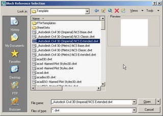
3. Go to the marker tab
4. Check on the option to Use AutoCAD BLOCK symbol for marker
5. Right click in the white space and select Browse
6. In the Browse to file window, change your file of type to *.dwt
7. Browse to your Template file that has all the styles you want
8. Select it and open it.
9. Select OK to apply the changes.
10. Viola! All the styles, and I mean all of them, are imported into the current drawing, label styles, object styles, part lists…everything in the settings tree of Toolspace.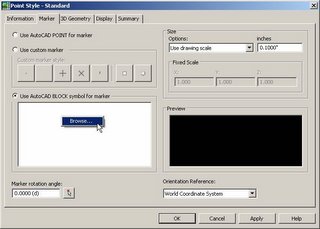
And with that, I am outta here until tonight. I have some work that has to be done during daylight hours and after that I have an appt with my therapist to talk about my obsession with blogging.
Posted by Dana at 6:47:00 AM 4 comments
Thursday, July 06, 2006
Diversions from the Summer Reading List and my New FAVORITE Marine Mammal
 So I like to read.... And I picked up a book the other day and plowed through it quickly despite the fact that it was not on the Summer Reading List.
The book is called The Hungry Tide and it is set in a place that I had never heard of... the the Sundarbans. It is a great story about a young Marine biologist studying dolphins in one of the most fragile wetlands areas in the world.
But it ain't just a tree hugger story (although the heroine does wind up huggin a tree during a storm) it has love, romance, infidelity, exotic food and a man eating tiger. Good fun!
BUT these aren't your normal Flipper-esque boring old dolphins. These are the cutest, weirdest looking creatures you ever saw in your life. They have round heads, stubby fins and a smile that seems to be laughing at you (where Flipper is obviously laughing at himself).
They are called Irrawaddy Dolphins and I can't believe that I have lived 30 years and four weeks and never heard of them before.
Think of all the other animals we have never heard of.... Maybe we need to Design Like We Give a Damn
Posted by Dana at 8:27:00 PM 0 comments


