
I need your help.
I keep getting these Fatal Errors while using Civil 3D 2007 SP1A with Pipe Networks.
FATAL ERROR: Unhandled Access Violation Reading 0x001c Exception at f0ec880h
FATAL ERROR: Unhandled Access Violation Reading 0x001c Exception at effc880h
FATAL ERROR: Unhandled Access Violation Reading 0x001c Exception at f0ac880h
FATAL ERROR: Unhandled Access Violation Reading 0x001c Exception at ef0c880h
Here is the scenario: I lay out a quick storm pipe network. Then I realize that I chose headwalls instead of catchbasins. So I go back through to replace them and I get crashmagic land. I can get it to repeat, I can document it.
But Autodesk can't. I sent them my drawing and my how to, and they can't get it to repeat.
So, I ask you, faithful reader. If you get either of these fatal errors in a similar situation, please let me know so that I can get you in touch with the right people at Autodesk so that we can get this one fixed.
The good news is- I documented another fatal error this week that they were able to repeat and a fix is on the way.
FATAL ERROR: Unhandled Access Violation Reading 0x0004 Exception at 64555170h
This one occurs when you are using the Connect to Part tool and accidentally try to connect a part to itself. So for now, be careful when using that tool.
Friday, August 25, 2006
FATAL ERROR OF THE DAY: Pipe Structures
OK, SO WHY do we NEVER migrate parcels?
I had a break in the excruciating emotional minutiae that is my life the past few weeks, so I was able to throw together a quick appeal to ALL Civil 3D users out there who have fallen into the temptation of migrating parcels from Land Desktop, importing parcels from LandXML or creating parcels from closed polylines.
I need to get off my duff and post a "Fundamentals of Topology" which may demystify some of this... but until then...
Read my article at Civil3d.com on this subject.
Parcel Migration and Parcel Import- Don't Let them Bite You
Wednesday, August 23, 2006
DO NOT MIGRATE PARCELS FROM LAND DESKTOP
FOR THE LOVE OF GOD
DO NOT MIGRATE PARCELS FROM LAND DESKTOP INTO CIVIL 3D.
I don't have the energy to explain right now. Just don't do it. Ever.
Here is why:
Parcel Migration and Parcel Import- Don't Let them Bite You
Autodesk Collision Tour September 19 Philadelphia
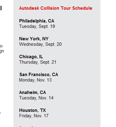
Autodesk Infrastructure Collison Tour
Coming to a city near you... I'll be in Philadelphia to check out Pete Kelsey's presentation, and possibly New York to sit in on Geospatial as well.
Come on up and say Hello!!
Agenda
8:30 a.m - 9:00 a.m.
Registration and Continental Breakfast
9:00 a.m.- 10:15 a.m.
Welcome and General Session
Keynote Speaker: Chris Bradshaw, V.P., AutodeskChris will help you learn more about Autodesk's integrated infrastructure solutions and how your organization can connect GIS and CAD data, systems and tasks. He'll explain how new technologies like dynamic modeling save you money and time and how open systems help you to connect your existing data formats and applications to other legacy systems. He will also discuss how industry trends like open source software will change the way you work.
Chris will help you learn more about Autodesk's integrated infrastructure solutions and how your organization can connect GIS and CAD data, systems and tasks. He'll explain how new technologies like dynamic modeling save you money and time and how open systems help you to connect your existing data formats and applications to other legacy systems. He will also discuss how industry trends like open source software will change the way you work.
10:15 a.m. - 10:30 a.m. Break
10:30 a.m. - 12:00 p.m.
Breakout Sessions:
GIS Professionals
See the latest geospatial software featuring CAD and GIS interoperability using a central database. Discover the geospatial features that mapping technicians require -- polygon overlay, table editing, and more -- plus multi-user editing, direct access to live data sources, and even map publishing on both web-based and mobile devices. Hosted by:Pete SouthwoodGeospatial Technical SpecialistAutodesk, Inc.
Civil Engineering
See the civil engineering design software that delivers proven power and outstanding interoperability to complete transportation, site, sewer, storm drain, and subdivision projects with production plans produced directly from a dynamic engineering model. Hosted by:Pete KelseyISD Technical EvangelistAutodesk, Inc.
12:00 p.m.- 1:00 p.m. Learning Lab
Tuesday, August 22, 2006
Civil 3D Companion: MySpace for CAD Nerds
It is hard enough to meet new people these days, let alone while you are glued to your seat exploring and learning Civil 3D.
There is a new service out there to match people who are looking for fellow Civil3Disciples to bounce ideas off, collaborate with, play LAN Ghost Recon and meet up for anime marathons.
Think of it as Friendster, only Geekster.
I have found a few listings of interested from this brand new Civil3D Companion service. "Seeking to Align you on the Correct Site"
ASSEMBLY SEEKING BASELINE
5'9"ish Mechanically inclined but Civil just the same.
I am looking for someone to steer me down the right path- both horizontally and vertically. If you have tight curves and varying grades you could help set my targets. I'm working through a transition right now, so I need someone patient who can watch me build and extract volumes of good material from me.
Likes: daylighting, VBA
Dislikes: Incomplete profiles, Subassemblies created from polylines, AutoLISP, HTML
Other interests: Partsbuilder, Vault
READY FOR A UNION
5'10" Long blonde hair. Degreed engineer, Obsessive topologist.
Hobbies: Crosswords, jigsaw puzzles, quilting, puns, screen capturing
Seeking IM buddies for late night chats, inside jokes, metes and bounds, and blogging banter.
I want friends that see beyond my normal function and take advantage of my hidden talents. I am more than just what my default label might lead you to believe. If you want a report on all of your areas, I don't mind doing the calculations for you.
I might be senstive, but respect my rules and I will pay off huge in the long run.
Candidates must be able to produce a span label on the first try.
Likes: Civil 3D, Lots lines perpendicular to the ROW
Pet Peeves: Overlapping Edges, Sleep, Fatal Errors, Hex Dumps, Fatal Errors, Feature lines reacting with site geometry, BUG REPORTS
Fears: The PE Exam
Other interests: None
ALL AROUND ROCKSTAR
Approx 6', (6'1" in Cape and Tights).
I'd like to find some like minded folks to chill with while rockin' out and hecklin' at AU.
Start in the beginning and just download all of your information on me, I will carry you through the whole deal. We'll process the real world together and make any adjustments you need to make life easier. Let's divide and conquer, get things aligned and take a look at what is going on below the surface.
Likes: Telling it like it is, getting the job done, finding a solution
Dislikes: Span Labels, Desc Key disappearance
Other interests: DG
Monday, August 21, 2006
Civil 3Delicious: Piping Hot Pulled Pork Pot

It's been a little while since I have had a chance to cook. Busy with Panorama, Civil 3D and life in general.
Mr. P. and I drove all night Wednesday and arrived the the grocery store at 3PM Thursday famished. We swore we would never go hungry again!
So I loaded up on things that I could make ahead and munch on all weekend.
This weekend's projects was pipes, as you may gather from Nick and my posts at www.Civil3D.com.
So as I sketched, imported, exported and generally piped my brains out, I would occasionally find my way into the kitchen and make a sandwich.
To learn more about my weekend piping adventures moving designs in and out of excel, check out my article Inverts Inverts Everywhere
This is a recipe even a frat house could pull off. A real man's meal.
PIPING HOT PULLED PORK POT
1 Cheap Pork Roast (like a shoulder). Fatty is OK!
1/2 cup-ish of soy sauce
1 tsp-ish of chopped garlic
1 cup +/- white wine or apple juice or white grape juice
2 cups +/- water
Salt, Pepper, Seasoned Salt, spices to taste
1 medium to large sized bottle of BBQ Sauce
hamburger or sandwich rolls
Sprinkle roast with salt, pepper, etc. Put in crockpot. Add soy sauce and garlic. Add wine/juice. Add additional water to come close to covering the roast.
Cook in crockpot on low for approximately 8 hours, or until pork is done and shreds easily with a fork.
Remove pork from pot, shred with a fork.
Pour liquid from pot into a large bowl.
Put pork back in pot. Add BBQ sauce. Use cooking liquid from the large bowl to thin the BBQ sauce as desired. Discard extra liquid.
Cook a few more minutes in crockpot unitl BBQ sauce is warmed up.
Make sandwiches for days.
Sunday, August 20, 2006
Rejected names for CAD and Coffee
Just a reminder about the CAD and Coffee at Cadapult this Tuesday, 8:30AM
Topic:
A section of the Civil 3D 2007 for Stormwater Management Tasks presentation that I will be giving at Autodesk University
For signup info check out
CAD and Coffee August 22
For fun, here are a list of names that were rejected for the CAD and Coffee. Let me know what you think- and if you have any additional ideas:
CADfiends and Caffeine
ICE'd Tea
Modern Model Mornings
Breakfast Epiphanies
Brunch with the Stars
Green Eggs and CAD
Once upon a CAD
CAD omlette
Big Bowl O’ CAD
Top O’ the CAD to ya!
CADamuffins
Model Based Muffins
Cuppa CAD
CADabreakfast
CAD: Ain’t just for breakfast anymore
CAD coffee caucus
Picks, clicks, swizzle sticks
Model-Based Design and Donuts
Wakeup to CAD
Coffee CAD Click
Breakfast Tricks
And for the Buildingly Inclined:
BIMs and Beans
Fill it to the BIM
Raisin BIM
Sunday Morning Book Shopping
Mr. Probert is studying for the P.E.
This morning he handed me a list of resource books he needed. He hates this stuff. I, on the other hand, live for that satisfying crackle noise of a new hardback. Or better yet, pondering the mysterious life of a used book- who owned it? Did they love it? Did they read it in the bathtub?
So it was a perfect opportunity to stock up on some of the books I had lingering in my amazon shopping cart.
Here is a list of books that will be showing up on my doorstep in 3-5 business days.
Nothing gives me the warm fuzzies more than coming home to a nice heavy box of books on the doorstep.
Surveying & Layout Fundamentals for Construction (DVD)
I am feeling the need for a refresher, and this DVD comes highly rated. My layout experience is limited to one hideously cold autumn in Edmonton with the world's coolest party chief, Cam F. and his sidekick Brad. Brad and I fought like brother and sister, and I never could get the rod level. Lesson learned: Party Chiefs can read lips through the sight, so keep the cursing INSIDE your head.
Civil PE Sample Examination
More ways to ruin a perfectly good weekend. It will be my turn in April.
Six-minute Solutions For Civil PE Exam Geotechnical Problems (Civil Engineering)
Seeing Mr. P's geotech study sheet inspired me to do a LL test on some playdough Panorama had laying around. I am still trying to figure out how I can run a triax on it. I spent the better part of the Fall of 1998 pounding proctors so just seeing the density curve still makes my hand hurt.
Six-Minute Solutions for Civil PE Exam Problems: Water Resources
Weirs, channels, swales, retention, yadayada- it all boils down to ditches and puddles.
And to cap it off, my recent obsession with the "perfect" surface led me to these choices:
Topographic Surveying (Technical Engineering and Design Guides As Adapted from the Us Army Corps of Engineers)
Topographic Surveying and Geodetic Control Basics Manual Cd [CD] [Software]
Topographic manual [Unknown Binding]
Modern Topographic Drawing
Civil 3D: Are you thinking the right way to make the best of it?
You may have experimented with Civil 3D and found it frustrating.
Perhaps you encountered a steep learning curve yet didn't quite see the payoff.
If you are considering Civil 3D, or are having trouble getting into the groove, check out the article I wrote for www.Civil3D.com last week: Rethinking Your Approach: Stone Sculpture vs. Clay Model
Many of us, especially those who have been around since manual drafting was phased out, approach our designs like we would a stone sculpture: Don't start drafting until the design is straightened out. Each chisel stroke is permanent and difficult to fix.
Where Civil 3D really works best when you approach it like shaping clay- build your model, backup, build again, experiment, iterate, iterate.
Which paradigm are you in? Read the article and find out.
Saturday, August 19, 2006
Farewell to Nova Scotia

It has been a long time since I have been somewhere that was so peaceful and lovely. The southeastern corner of Nova Scotia is amazingly quiet and quite untouched.
Most of the time, we were the only ones on the beach. The water was colder than Delaware, but not intolerable.
There was one beach that had extremely shallow water that extended very far out, so the water there was warm and we could explore the whole bay floor.
The company was fabulous, too. Mr. Probert's family has the house on the water, and cousins, uncles and aunts from Toronto, England, and Arizona came out for a bit of a reunion.
I mentioned before that most of the family there were either engineers or work in the construction industry, so no family get together is complete without a tour of the local infrastructure.
We were saved from a visit to the sewage treatment plant by the presence of a wind farm near Pubnico. The wind farm was one part beautiful, one part awe inspiring, and one part weird as hell.
Being the nerds that we are, we clocked one revolution, wrote down the measurements of the blades, and took bets on velocity at the tip.
Then, we went back to the beach house and calc'ed it out.
Brother-in-law won. But I was pretty close.
Rainy days and quiet evenings were filled with Su Duko, crosswords, all too serious games of Whist, and for me, corridor modeling. I also brought a few back issues of POB, Urban Land, and the ASLA magazine which were passed around with great enthusiasm.
We managed to limit the NDP vs. Bush Redneck debates over dinner to one per evening by keeping the sherry glasses full, and at least once I purposely dropped a plate in the kitchen as a diversion when the subject of socialized medicine came up.
Before the final run to the border, I picked up a few things that are just better in Canada- yogurt, Mars Bars, Kinder Surprise, Fuzzy Peach, Toonies, good cheer, friendly smiles and a few lungfulls of sweet northern air.
I shall return, there is no doubt.
Farewell to Nova Scotia, you sea-bound coast
Let your mountains dark and dreary be
For when I am far away on the briny ocean tossed
Will you ever heave a sigh and a wish for me?


More...Create a Table of X,Y,Z Coordinates from an Alignment: Method 1
As I mentioned in my post If it quacks like a duck, anything from propector that looks like a spreadsheet can be pasted into excel for further reporting, and "prettification".
But an under-used tool, in my opinion, is the AutoCAD table. I will be using the AutoCAD table hard core in some of my SWM papers and presentations, and many other applications. They support simple formulas, can be used with attribute extraction and much more.
I also use a method similar to this for some more detailed parcel analysis and breakdowns, so use your imagination.
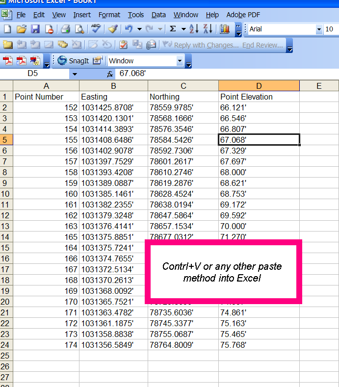
Make additional columns to show whatever you want, in this case I added some stationing.
There are some neat Excel commands like CONCATENATE that can help you do things like specific station formatting.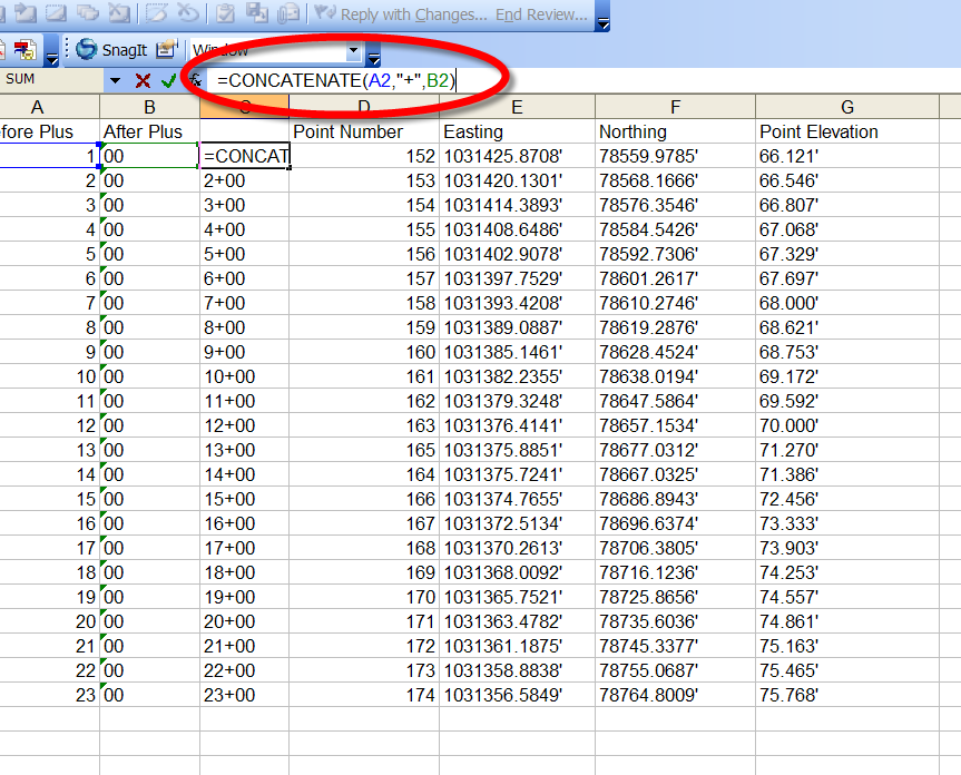
In AutoCAD/Civil3D, paste special.
Choose AutoCAD Entities from the paste special dialog box.
These tables can be edited, added to, etc. The possibilities are endless.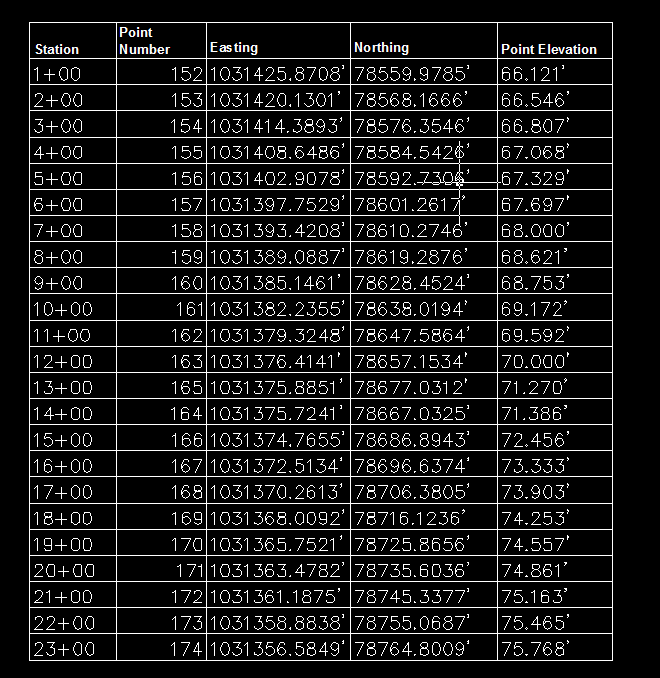
Create a Table of X,Y,Z Coordinates from an Alignment: Method 1
The question came up on the Civil 3D discussion group today:
If I have an alignment
and a Surface
Can I make a table that pulls out the X, Y and Z at each station?
Here is one method- I am still working on another one, because you will see there are two minor annoyances.
1) Create a Surface Profile from your Alignment. You won't have to do anything with this, Civil 3D just has to think about your surface with respect to your alignment.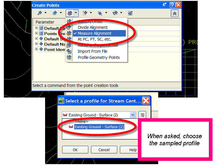
2) Points>Create Points. Use the Measure Alignment Option. Choose your sampled profile for the elevations. Follow the command prompts.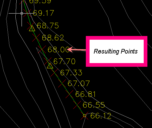
3) Make a Point Table style that shows Point Number, Northing, Easting, Elevation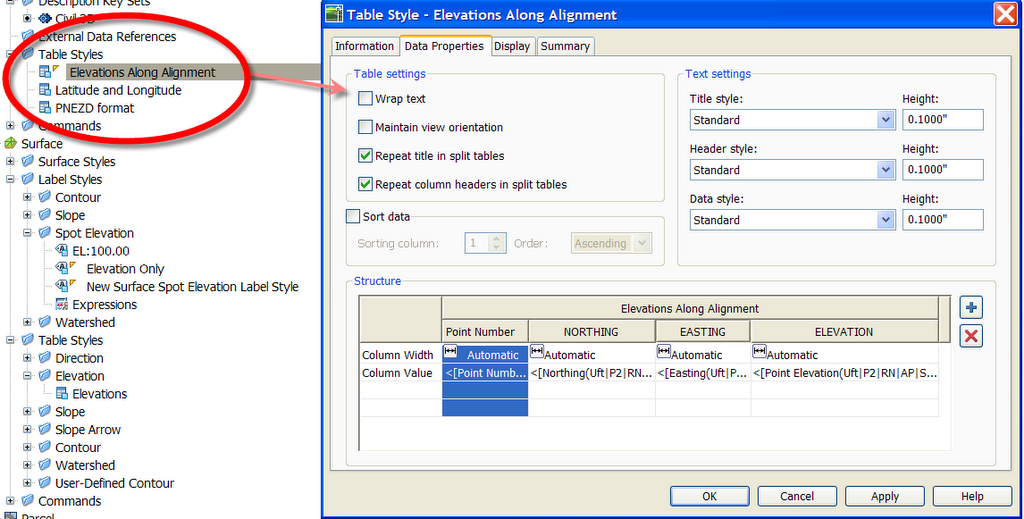
4) Make a Point Table
Annoyance #1
Points from a surface, unlike surface labels, are not instantly dynamic to the surface. Moving the point or changing the surface will not immediately update it. If your surface did change, you could always Points>Edit>Elevation from Surface. Once you do that, your points will update and your table will, too.
Annoyance #2
Points can't have references, so I can't (at press time) figure out a way to get the Alignment Station in the Point Table. It would be easy enough to just remember that Point Number 1 = Station 1+00, etc. but that bugs me. You could also name each point in the name column of the Prospector with its station, which is what I show below. If there were only a handful of stations, this is what I would do.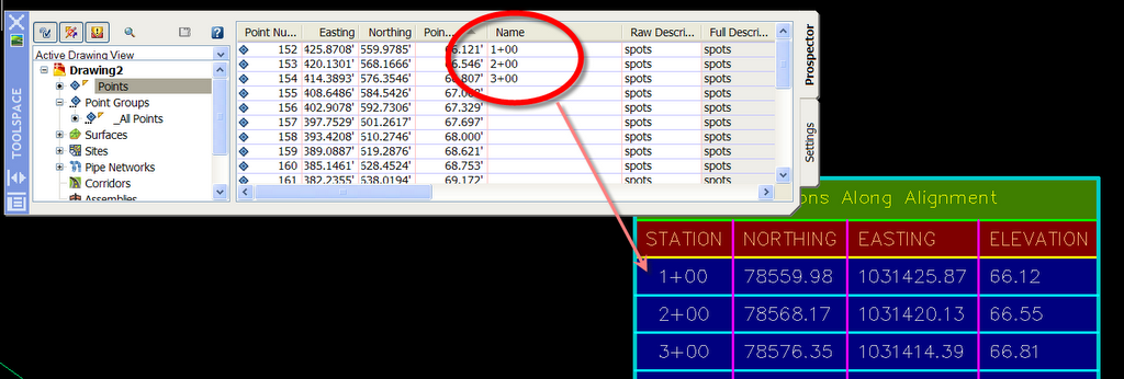
There are a few other things we can mess with here- involving excel, an autocad table, an empty roll of toilet paper and a small amount of nitroglycerin, so I will post an update later today. This one is better than Su Doku.
Friday, August 18, 2006
To Rock... or Not To Rock
You may also have heard of a little blog called www.Civil3D.com
Apparently, the guys over there are having trouble keeping their feet off the furniture and their drinks on coasters, so they are seeking a bit of a Diva touch.
I have been invited to contribute content to Civil3D.com.
In all honesty, I was quite dumbstruck when "the" James Wedding invited me to join Civil3D.com as a contributor- I mean, little ol' me?
So....
Should this Hermit Crab switch to a roomier shell?
Should I keep Civil 3D Rocks alive? or just move all of my content over to Civil3D.com?
Tell me what you think.
This reminds me of a quote from one of my favorite films of all time Drop Dead Gorgeous
"...Mom always says, 'Don't ever eat nothin' that can carry its house around with it. Who knows the last time it's been cleaned..."
HEC RAS tools for Civil 3D
You might have read or seen that I am doing a flood plain and river class at Autodesk University.
As part of that class, I will be showing a little program that automates the export of river sections from a Civil 3D river alignment to HEC RAS, as well as importing the RAS analysis data back in.
I beta tested this program a few weeks ago and found it to be easy to use and did a great job of getting data back and forth without leaving the Civil 3D environment for the export/import. Of course, I still had to to the analysis in HEC RAS.
There is a trial version available, and I would love to get some more real world feedback on the program before I show it during my AU presentation.
So if you use Civil 3D or even Land Desktop (and are willing to try that unused Civil 3D seat!) follow this link to download the trial version.
EE RAS TOOLS
Thursday, August 17, 2006
CAD and Coffee at Cadapult August 22
For those of you who live/work nearby,
CAD and Coffee Event at Cadapult, Ltd. in Newark, DE on
Tuesday, August 22, 2006
8:30AM to 11:30AM
No Charge
http://www.cadapult.net/company/newsevents.htm
RSVP to (800) 332-9961
Speaker: Dana Breig Probert
Agenda:
A section of the Civil 3D 2007 for Stormwater Management Tasks presentation that I will be giving at Autodesk University
1) Creating and Analyzing a Surface to delineate your subcatchments
2) Creating parcel styles and leveraging parcel labels and tables to assist in determining Subcatchment Areas, Soil Types, Cover Types, and performing calculations.
Also:
§ Discussion of the Civil 3D Certified User Class Curriculum and Examination
§ As well as AutoCAD Certified User and Certified Expert Curricula and Examinations and Autodesk University
§ Your questions and answers
You may have heard rumblings about Autodesk finally offering Examinations so that you can prove your skills in AutoCAD and Civil 3D. We’ll talk about these exams after the main presentation.
**This will be a monthly event!! Location and Agenda will vary- so stay tuned!**
Friday, August 11, 2006
Notes from Nova Scotia
The beauty of a socialist country is that every library in every small town has wireless. The librarians here seem not to know what to do with me, but eventually we figure it out and I get a password. It is wonderful to look out at the bay and keep in touch with life back home.
The trip was great- 13 hours from Millsboro to Bar Harbor, a quick but expensive ferry ride, then a scenic jaunt up the Lighthouse Scenic Highway to Mr. P's uncles house right on the water.
We have already had a conversation about GIS- Aunt and Uncle are a retired Planner and Engineer respectively and they occupy themselves in the winter on volunteer municipal support missions, most recently to Cameroon, where Uncle and his $100 handheld GPS are singlehandedly mapping the country. So I am here at the library seeing if I can't get him a dataset or two.
Lobster is on the agenda for tomorrow as the British contingency arrives this evening.
See you around the corridor...
Wednesday, August 09, 2006
You know you need a break when...
We are headed out tomorrow for a trip to Nova Scotia.
I informed Mr. Probert that I would be doing nothing but sitting in a chair, watching the ocean and eating lobster. I would NOT be running around sight seeing.
So Mr. Probert told me that I was not allowed to be an SRBM.
Apparently this is engineer code for "wet blanket".
Our trip will be wonderful- but we are meeting up with a collection of relatives that includes:
1-Urban Planner
2-Electrical Engineers
1-Nuclear Engineer
1-Concrete Manufacture
1-Construction and Building Supply professional
So as you can see, I will really "get a break from it all"
(I did check- no worries- the Yartmouth Library has WIFI)
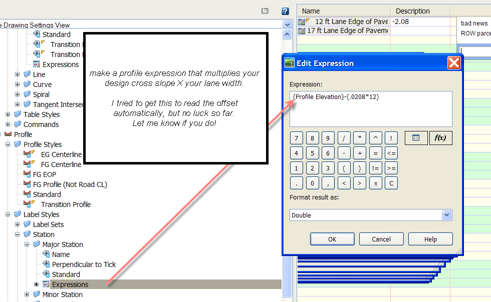
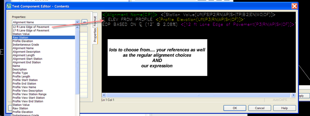
Using Expressions and References to Help you Design with your Model
Anyone who has tried designing an intersection knows what kind of a book keeping nightmare it can be- on paper, in LDT or in Civil 3D.
This weekend, I tamed about 30 intersections in a project I was working on, and I developed a few labels to help me make sure my grades were matching and following my design intent.
I used two things that are new to Civil 3D.
1) Expressions- take object data "harvested" from Civil 3D objects and build a formula. For example, I wanted to know the design elevation at my edge of pavement based on the centerline profile elevation. So I make a label that is Profile CL Elevation- (Lane Width X Cross Slope)
2) Object References- we'll be using an Alignment Station/Offset label, but referencing two profiles, a surface and through one of the profiles some alignment information. Pretty wild.
Here it is in action: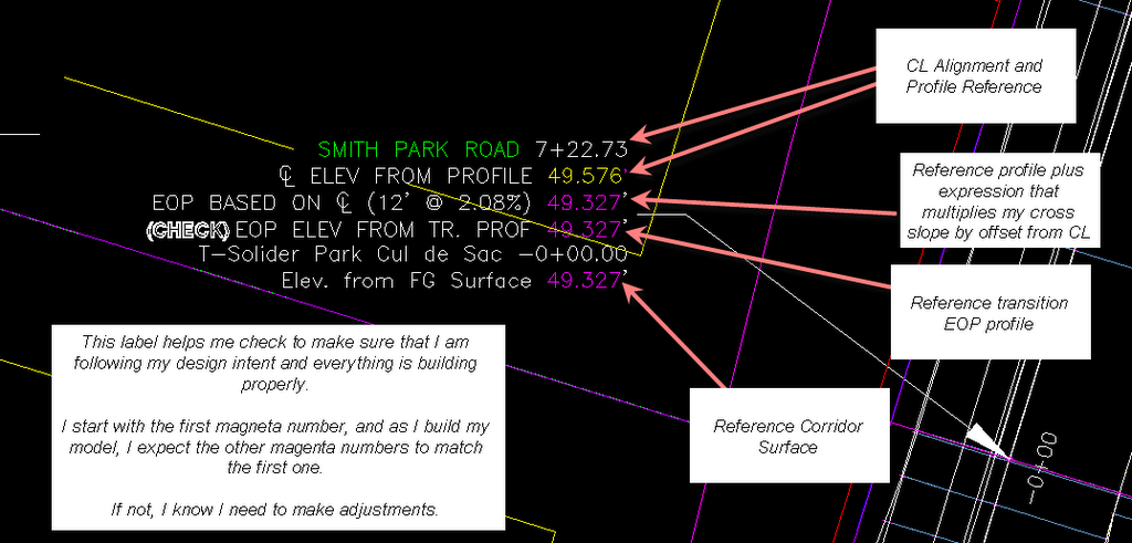


Here is another label along the same lines to keep your profile intersections matching:

Tuesday, August 08, 2006
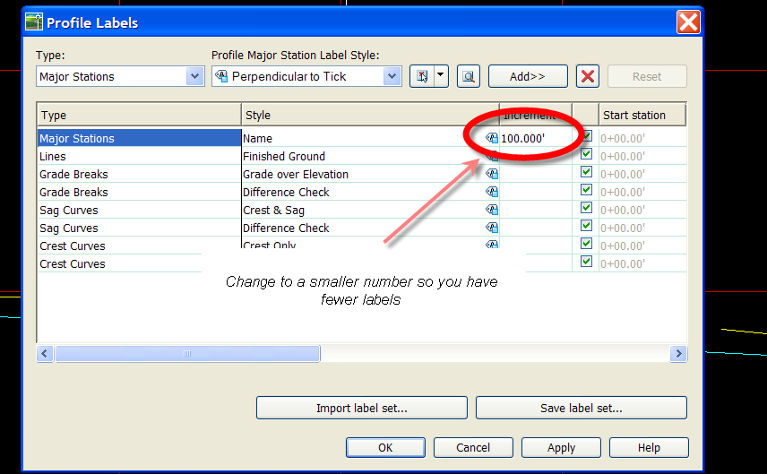
Making a Profile Name Label
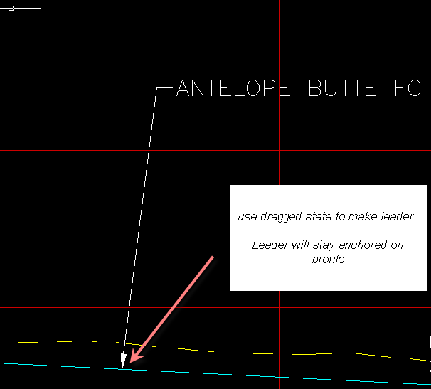
I was asked the other day if there is a way to make a "smart leader" that will follow a profile line as it is edited.
If you do it with a Profile VIEW label, the label won't move.
But you can make a major station profile label that calls out the name of the profile, or anything else. And it will do the job.
Make a Major Station label that calls out what you want, then either add it to your label set before making the profile, or add it afterwards. Here are some captures:

See also a related post: Labeling Elevation at Any Point Along a Profile and At Regular Intervals Along a Profile
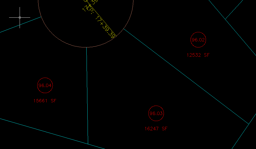
Using an Expression to make a Decimalized Parcel Area Label
Let's say you are working on a bigger parcel--- Lot 74.
Your county wants you to show all of the lots that are divisions of Lot 74 as 74.01, 74.02, through, say 74.26.
But Civil 3D won't let you do decimal parcel numbers, and naming each one is a pain.
So here is a fix that might help. It may not be the only solution, so post your comments and ideas!
1) Do all of your subdividing and just live with the numbers as they stand temporarily.
2) Then use rename/renumber tool to number your lots 7401, 7402, 7403, through 7426.
3) Make an expression that divides PARCEL NUMBER / 1000 (or /10 or /10000 as necessary).
4) Make an area label that uses your EXPRESSION instead of PARCEL NUMBER as the label.
Here are a few captures to help:

Sunday, August 06, 2006
Tips for Lively Conversation at Autodesk University
Registration opens Monday for Autodesk University!
Register Here
You can sign up and choose your classes. Last year, you didn't have to pay right away, I am not sure if that works this year as well. So you can sign up, get the classes you want and you might have a few more weeks to talk the boss into footing the bill.
If you are looking for some free entertainment at AU, try sidling up to a happy group of CADDers in the cocktail lounge and try one of these conversation starters:
"I really prefer a UCS rotation to a dview twist. Especially for Civil projects."
The UCS vs Dview twist argument rages on. Both camps have their reasons. Neither is letting go. This one has started at least one barfight every AU since 2000i.
"Mtext is far superior to Dtext"
Both dtext and Mtext have their place in this world. Nothing has that solid snappy insertion point quite like dtext, but if you have ever faced a 2000 word specs and notes sheet in dtext you know true pain. I think each one has their place, but every firm I have ever worked for or with wants to "pick one" for universal use. All that winds up happening is fist-to-cuffs over the CAD management lunch, followed by angry silence, and everyone going back to their desks and using whatever they feel like- just for spite.
or my personal favorite:
"Civil 3D isn't unstable. The Problem is Between the Seat and the Keyboard "
If you feel the need to say this, bring body armour or be sure to be carrying a puppy, cause otherwise you will have the literal crap kicked out of you. Trust me, I know. I made a lame attempt at some dry humor on the Civil 3D discussion group a few months ago and any day now the doctor should be able to take the wires out of my jaw.
While many errors and problems in Civil 3D can be mitigated by a good understanding of what the program expects from you from a data and input perspective, there is never an excuse for a program to kick you out with no explanation.
My take on it- I wouldn't do work any other way. I am currently working on a few 100+ lot subdivisions. I spent the weekend designing roads, making corridors and pipe networks. I have had minimal problems because I know how to keep my drawings clean and create things that Civil 3d likes.
Is it perfect? No.
Is it bad enough for me to go back to LDT (which for me was about 60% LDT tools and 40% manual text, dimensioning, etc) NO WAY.
In about 25 hours of work, I have 15 roads just about fully designed. And even if we find things that need adjustment due to SWM issues, etc. now I just feed my model the new grades instead of erasing everything and starting over or trying to keep track of what changed and what didn't.
Come to Autodesk University and fill your brain with knowledge that will help get you there.
Topics that no longer get the color up (I hope):
"Paper Space is Useless"
Once the biggest bench clearing comment that could be made in an room full of CADDers, folks these days have calmed down a bit and figured things out. Now that the cryptic "1/100 xp" rigormorole is not necessary, things have gotten easier. Every once in awhile I run into someone who has be inadvertently been working in floating model space for two years, but it is rare.
"Only idiots don't use full sized crosshairs"
I actually had someone say something along these lines to me this winter while I was teaching a class. I don't think I have had my crosshairs bigger than a peach pit since I took my first AutoCAD class in Winter 1996 on a SPARC station. But I don't think I have ever noticed nor cared what anyone else uses until this comment. Regardless, most of realize this argument is about as pointless as a pink command line. To each his own, I say. User preferences are just that- user preferences.
Saturday, August 05, 2006
A potential site geometry issue with transitions
If you use secondary alignments to represent your edge of pavement or similar, keep in mind that those are also alignments that are working with (or against) your site geometry.
I am currently getting around any potential "divisions" of my ROW parcel by making a site called "Transition Alignments"
To further throw a wrench into it- imagine if you had a transition alignment in your corridor and then extracted that edge of pavement feature line from the corridor model. That is two "site geometry lines" DIRECTLY over top of one another- a topology NO NO.
So make a transition alignment site and keep your feature lines on a grading site.
Friday, August 04, 2006
Which Aerial Topo Drawing do I use to build my TIN?
When you receive aerial topography, you are often presented with two drawings.
1) Contours and Features (trees, buildings, etc)
2) DTM (softbreaklines, hardbreaklines, obscured breaklines, points)
Most people ignore the DTM drawing because it looks unfamiliar. Land Desktop made it a little bit difficult to build surfaces from those little bits of text or acad points that come in the drawings (it was possible to use them, but a little digging to find out how).
Most people build their surface from the contour drawing. We all understand contours and building a surface from contours is very straightforward.
Depending on your aerial topography company, the DTM drawing is actually the raw material from which they create the contours. So the DTM is the better source for surface data. (If your aerial topo company does not provide you this drawing, ask them what they might be able to give you instead, like perhaps LandXML, a TIN or a grid surface)
Also note that I have been in many offices in this region and asked the engineer for the DTM drawing- and they say they don't get one. But when we look on the disk provided by the aerial topo company, there is actually a DTM drawing in there. They just didn't ever go looking for it or notice it.
I wanted to see if there were other reasons why a person should consider using the DTM drawing.
So I did a little experiment. I took the contour drawing and DTM drawing from a site, and built surfaces from each to compare.
I had some problems uploading images to blogger over the weekend, so click on these images actually takes you out to flickr. It didn't work quite as well as I had hoped, so I hope you can still make out what I am trying to show.
Then, I applied the minimize flat areas tools to the contour surfaces to see if that would make a difference.
The results?
Using the DTM Created Surface as the "baseline", it is pretty clear that using a surface created from contours is certainly different. Minimizing flat areas didn't really make a difference, and weeding made the difference larger for sure. But what i found interesting is that the biggest jump is from DTM to Contours. Weeding the contours certainly make the gap larger, but not as big a gap as from DTM to Contours.
Why does this matter? I don't know. Have a talk with your aerial topography company and find out what they recommend. Perhaps they can give you a DTM drawing. Other acceptable data sources would include: 3D Grid, 3D Faces, Polyface, .TIN file, LandXML and similar.


If it Quacks like a Duck
The question came as a comment to my last post about surfaces- how did I get those numbers into excel?
It is easy. In Civil 3D, if it seems to "Look like a spreadsheet", "Act like a spreadsheet", and "Quack like a spreadsheet" it can easily be taken out to Excel to become a spreadsheet.
Here's how.
Just use your shift key to select the cells you want to take out to Excel, and right click to choose "Copy to Clipboard".
Then go into Excel and choose paste. The cells you chose will populate excel in individual columns.
This works for anything that "looks like a spreadsheet"
So, Prospector, Panorama, etc. You can grab pipe lists, parcel lists, volume calcs, style names, etc.
Note that this is not a dynamic relationship, just a way to get things into Excel for you to manipulate.
Thursday, August 03, 2006
How much surface is too much?
There has been a lot of conversation in the Civil 3D community about large surface size.
One of the more common sources of large surface data files is aerial topography. Often, we are only provided with contours that have very close vertices. Sometimes we are able to get the DTM file or if we are really lucky the actual TIN or grid itself.
I have often had the experience of sitting down in an engineer's office and seeing what I would consider to be an unmanageablely large drawing. Upon inspection, aerial topography is the culprit.
I often recommend weeding the vertices of those contours before creating a surface from them and I am met with responses such as "we want to be as accurate as possible"
And I don't disagree with that. But I wanted to know exactly how much accuracy would be lost by doing a little bit of vertex elimination.
Here are some aerial topographic contours.
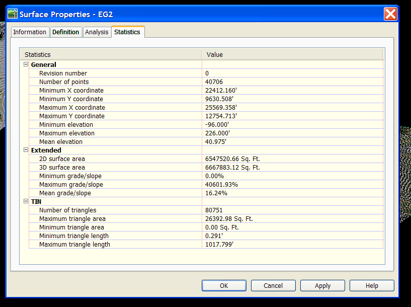
I built a surface from them "as is" called EG.
Then I weeded the contour vertices using the Map Cleanup>Simplify Objects command. I set the distance to 1ft.
Here are the results:
Drawing with nothing but EG surface in it: approx. 11 Meg
Drawing with nothing but EG1 surface in it: approx. 3 Meg
I made a flat surface at elevation zero to use as a comparison. I took a composite volume between EG and Flat, EG1 and Flat, and EG and EG1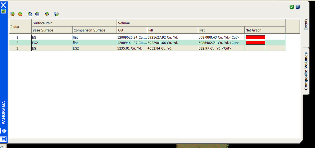
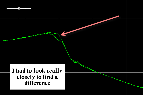
I also did a quick profile to see if there was a visible difference between the two surfaces. I did this a few places- here is just one of them. The results were similar- very few visible differences. And those that were visible were very small.
Here is a table of results comparing the two surfaces. (Note that you can click on it to see it larger).
Over the whole surface, 150 acres +/-, I discovered a difference of just about 3% in net volume.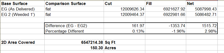
Is this significant? You tell me. You are the PE on the job.
But think about this: if those differences are not significant, you are bogging down your drawing with an unnecessarily large surface.
Also- consider that you can reduce the simplification factor. I did 1Ft. In the past I have worked with clients who used 0.5ft and it made enough of a difference in drawing size to make it worth it.
You be the judge- I'd love to hear your comments!!! Please let me know if I missed something here.
Wednesday, August 02, 2006
That's Just--- BSChronicle
This is an email I received today:
Dear Dana:
I read Civil 3D Rocks every single day. I really enjoy your off the wall sense of humor and your grasp of all things technical.
However, I have two concerns.
The first is that you are only occasionally sarcasitic. I really prefer a more dry and sophisticated sense of humor in my technical commentary.
Secondly, I am an engineer who designs buildings, and I have no use for Civil 3D.
Can you recommend a blog that will be more in tune with my needs?
Sincerely,
Joe Design, PE
Buildings & More, Inc.
I receive thousands of emails like this every single day. And I have never had anything to refer them to- UNTIL NOW!
Eric Kuszewski, the man who has the unfortunate privledge of sharing a cube with me on the rare occasion that I go in to the Home Office, has started a blog.
THE BSCHRONICLE
A collection of hints, tips, suggestions, and other sage advice for the use of Autodesk Building Systems and Autodesk Revit Systems.
http://bschronicle.blogspot.com/


